Usseglio elevation
Usseglio (Piedmont, Torino), Italy elevation is 1265 meters and Usseglio elevation in feet is 4150 ft above sea level [src 1]. Usseglio is a seat of a third-order administrative division (feature code) with elevation that is 943 meters (3094 ft) bigger than average city elevation in Italy.
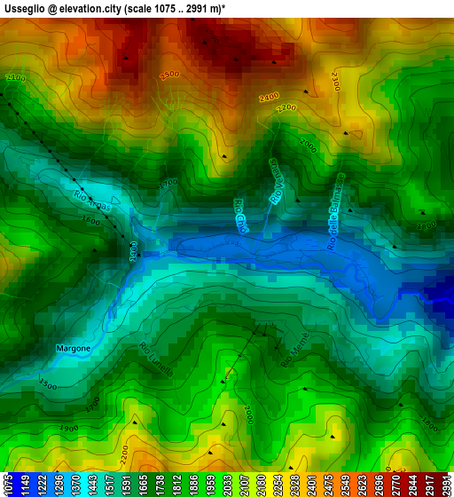
Below is the Elevation map of Usseglio, which displays elevation range with different colors. Scale of the first map is from 1075 to 2991 m (3527 to 9813 ft) with average elevation of 1872.7 meters (=6144 ft) [note 1]
These maps also provides idea of topography and contour of this city, they are displayed at different zoom levels. More info about maps, scale and edge coordinates you can find below images.
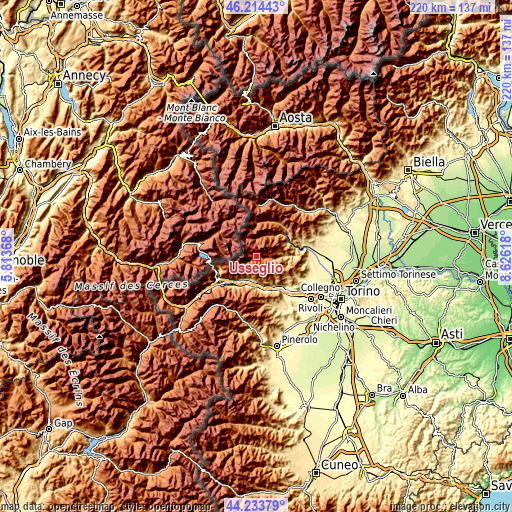
| \ | Map #1 | Topo.Map |
| Scale [m] | 1075..2991 m | × |
| Scale [ft] | 3527..9813 ft | × |
| Average | 1872.7 m = 6144 ft | × |
| Width | 6.88 km = 4.3 mi | 220.2 km = 136.8 mi |
| Height | 6.88 km = 4.3 mi | 220.2 km = 136.8 mi |
| ↑Max Latitude | 45.263679° | 46.21443° |
| Latitude at center | 45.23274° | 45.23274° |
| ↓Min Latitude | 45.201784° | 44.23379° |
| ← Min Longitude | 7.175985° | 5.81368° |
| Longitude center | 7.21993° | 7.21993° |
| →Max Longitude | 7.263875° | 8.62618° |
Nearby cities:
Cities around Usseglio sort by population:
• Bussoleno elevation 444 m
11.9 km,  209°
209°
• Villar Focchiardo 398 m
13.5 km,  173°
173°
• Baratte 403 m
13.5 km, 174°
• Borgone Susa 402 m
12.2 km, 173°
• Bruzolo 438 m
10.4 km,  190°
190°
• San Giorio 427 m
12.2 km,  196°
196°
• San Didero 438 m
10.8 km,  182°
182°
• Viù 773 m
12 km,  87°
87°
• Ala di Stura 1071 m
11.2 km,  35°
35°
• Chianocco 552 m
10.2 km, 202°
• Lemie 955 m
5.7 km, 94°
• Balme 1425 m
7.7 km,  359°
359°
Multilingual:
 En español:
Usseglio elevación 1265 m.
 En France:
Usseglio élévation 1265 m.
 Auf Deutsch:
Usseglio höhe über dem Meeresspiegel ist 1265 m.

Sources and notes:
- [note 1] Map square and city borders are not equal. Map elevation data is calculated only from area inside that square.
- [src 1] Elevation data from geonames database provided with same terms of usage.
- [src 2] The elevation map of Usseglio is generated using elevation data from NASA's 3 arcsec (90m) resolution SRTM data.
- [src 3] Base (background) map © OpenStreetMap contributors tiles are generated by Geofabrik and OpenTopoMap.
Copyright & License:
This Usseglio Elevation Map is licensed under CC BY-SA. You may reuse any part from this page, if you give a proper credit by linking to this URL:
 More info on terms of use page.