Linate elevation
Linate (Lombardy, Città metropolitana di Milano), Italy elevation is 107 meters and Linate elevation in feet is 351 ft above sea level [src 1]. Linate is a populated place (feature code) with elevation that is 215 meters (705 ft) smaller than average city elevation in Italy.
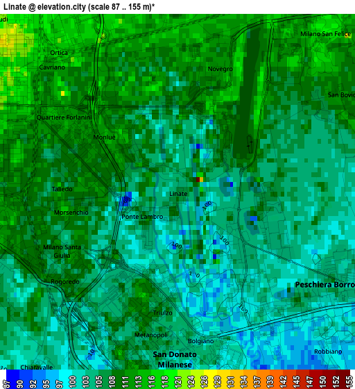
Below is the Elevation map of Linate, which displays elevation range with different colors. Scale of the first map is from 87 to 155 m (285 to 509 ft) with average elevation of 106.9 meters (=351 ft) [note 1]
These maps also provides idea of topography and contour of this city, they are displayed at different zoom levels. More info about maps, scale and edge coordinates you can find below images.
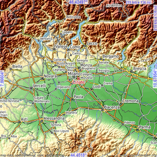
| \ | Map #1 | Topo.Map |
| Scale [m] | 87..155 m | × |
| Scale [ft] | 285..509 ft | × |
| Average | 106.9 m = 351 ft | × |
| Width | 6.86 km = 4.3 mi | 219.4 km = 136.3 mi |
| Height | 6.86 km = 4.3 mi | 219.4 km = 136.3 mi |
| ↑Max Latitude | 45.477832° | 46.42497° |
| Latitude at center | 45.44701° | 45.44701° |
| ↓Min Latitude | 45.416171° | 44.4518° |
| ← Min Longitude | 9.228345° | 7.86604° |
| Longitude center | 9.27229° | 9.27229° |
| →Max Longitude | 9.316235° | 10.67854° |
Nearby cities:
Cities around Linate sort by population:
• San Giuliano Milanese elevation 98 m
6.1 km,  166°
166°
• San Donato Milanese 107 m
4.1 km,  184°
184°
• Segrate 120 m
5.4 km,  21°
21°
• Bettola-Zeloforomagno 106 m
3.4 km,  122°
122°
• Novegro-Tregarezzo-San Felice 112 m
2.4 km, 16°
• Civesio 100 m
5.7 km, 184°
• San Bovio-San Felice 110 m
3.6 km,  60°
60°
• Vigliano-Bettolino 101 m
5.8 km,  105°
105°
• Mezzate 105 m
1.8 km,  101°
101°
• Poasco-Sorigherio 103 m
5.9 km,  213°
213°
• Millepini 112 m
5.7 km, 63°
• Chiaravalle 103 m
4.2 km,  217°
217°
Multilingual:
 En español:
Linate elevación 107 m.
 En France:
Linate élévation 107 m.


Sources and notes:
- [note 1] Map square and city borders are not equal. Map elevation data is calculated only from area inside that square.
- [src 1] Elevation data from geonames database provided with same terms of usage.
- [src 2] The elevation map of Linate is generated using elevation data from NASA's 3 arcsec (90m) resolution SRTM data.
- [src 3] Base (background) map © OpenStreetMap contributors tiles are generated by Geofabrik and OpenTopoMap.
Copyright & License:
This Linate Elevation Map is licensed under CC BY-SA. You may reuse any part from this page, if you give a proper credit by linking to this URL:
 More info on terms of use page.