Macugnaga elevation
Macugnaga (Piedmont, Provincia Verbano-Cusio-Ossola), Italy elevation is 1315 meters and Macugnaga elevation in feet is 4314 ft above sea level [src 1]. Macugnaga is a seat of a third-order administrative division (feature code) with elevation that is 993 meters (3258 ft) bigger than average city elevation in Italy.
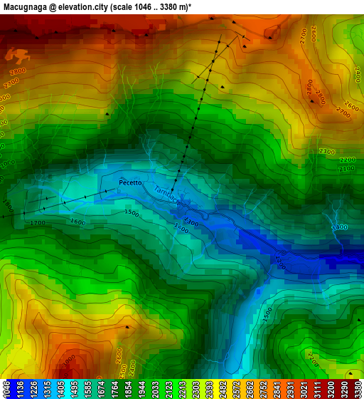
Below is the Elevation map of Macugnaga, which displays elevation range with different colors. Scale of the first map is from 1046 to 3380 m (3432 to 11089 ft) with average elevation of 2081.6 meters (=6829 ft) [note 1]
These maps also provides idea of topography and contour of this city, they are displayed at different zoom levels. More info about maps, scale and edge coordinates you can find below images.
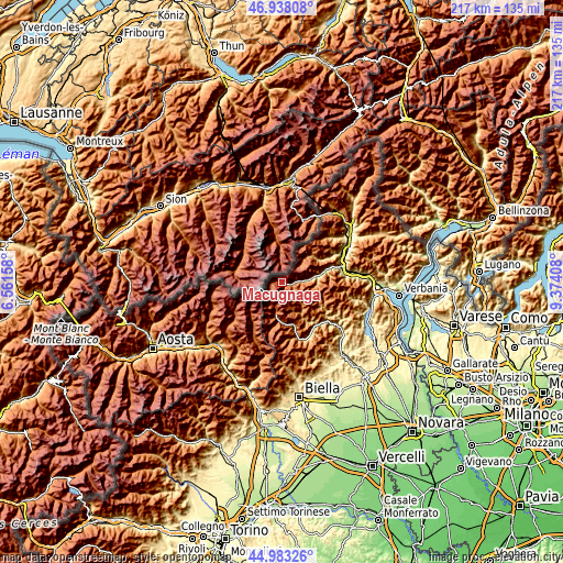
| \ | Map #1 | Topo.Map |
| Scale [m] | 1046..3380 m | × |
| Scale [ft] | 3432..11089 ft | × |
| Average | 2081.6 m = 6829 ft | × |
| Width | 6.79 km = 4.2 mi | 217.4 km = 135.1 mi |
| Height | 6.79 km = 4.2 mi | 217.3 km = 135 mi |
| ↑Max Latitude | 45.999825° | 46.93808° |
| Latitude at center | 45.96929° | 45.96929° |
| ↓Min Latitude | 45.938738° | 44.98326° |
| ← Min Longitude | 7.923885° | 6.56158° |
| Longitude center | 7.96783° | 7.96783° |
| →Max Longitude | 8.011775° | 9.37408° |
Nearby cities:
Cities around Macugnaga sort by population:
• Antrona Schieranco elevation 907 m
15.2 km,  48°
48°
• Antronapiana 914 m
15.3 km, 48°
• Alagna Valsesia 1170 m
13.3 km,  190°
190°
• Staffa 1311 m
0.1 km,  215°
215°
• Ceppo Morelli 761 m
7.7 km,  88°
88°
• Bannio 676 m
13.9 km,  83°
83°
• Vanzone 699 m
10.9 km, 84°
• Riva Valdobbia 1084 m
15.4 km,  183°
183°
• Rimasco 897 m
14.2 km,  148°
148°
• Carcoforo 1290 m
9.3 km,  136°
136°
• Fobello 883 m
17.1 km,  120°
120°
• Rima 1425 m
9.6 km,  165°
165°
Multilingual:
 En español:
Macugnaga elevación 1315 m.
 En France:
Macugnaga élévation 1315 m.
 Auf Deutsch:
Macugnaga höhe über dem Meeresspiegel ist 1315 m.

Sources and notes:
- [note 1] Map square and city borders are not equal. Map elevation data is calculated only from area inside that square.
- [src 1] Elevation data from geonames database provided with same terms of usage.
- [src 2] The elevation map of Macugnaga is generated using elevation data from NASA's 3 arcsec (90m) resolution SRTM data.
- [src 3] Base (background) map © OpenStreetMap contributors tiles are generated by Geofabrik and OpenTopoMap.
Copyright & License:
This Macugnaga Elevation Map is licensed under CC BY-SA. You may reuse any part from this page, if you give a proper credit by linking to this URL:
 More info on terms of use page.