Rimasco elevation
Rimasco (Piedmont, Provincia di Vercelli), Italy elevation is 897 meters and Rimasco elevation in feet is 2943 ft above sea level [src 1]. Rimasco is a seat of a third-order administrative division (feature code) with elevation that is 575 meters (1886 ft) bigger than average city elevation in Italy.
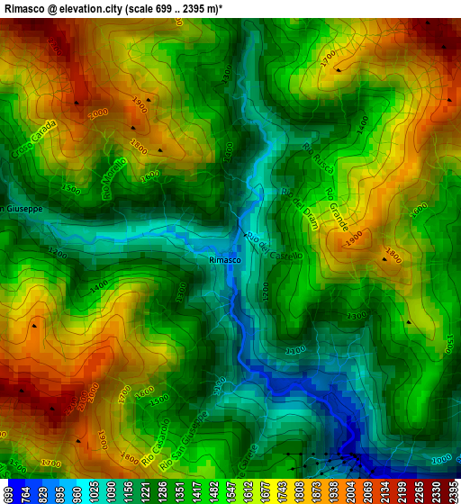
Below is the Elevation map of Rimasco, which displays elevation range with different colors. Scale of the first map is from 699 to 2395 m (2293 to 7858 ft) with average elevation of 1482.3 meters (=4863 ft) [note 1]
These maps also provides idea of topography and contour of this city, they are displayed at different zoom levels. More info about maps, scale and edge coordinates you can find below images.
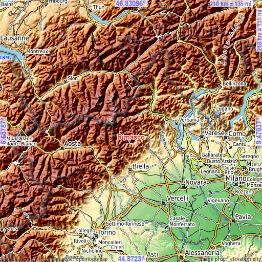
| \ | Map #1 | Topo.Map |
| Scale [m] | 699..2395 m | × |
| Scale [ft] | 2293..7858 ft | × |
| Average | 1482.3 m = 4863 ft | × |
| Width | 6.81 km = 4.2 mi | 217.8 km = 135.3 mi |
| Height | 6.81 km = 4.2 mi | 217.8 km = 135.3 mi |
| ↑Max Latitude | 45.890846° | 46.83096° |
| Latitude at center | 45.86025° | 45.86025° |
| ↓Min Latitude | 45.829638° | 44.8723° |
| ← Min Longitude | 8.020175° | 6.65787° |
| Longitude center | 8.06412° | 8.06412° |
| →Max Longitude | 8.108065° | 9.47037° |
Nearby cities:
Cities around Rimasco sort by population:
• Alagna Valsesia elevation 1170 m
9.8 km,  264°
264°
• Scopa 617 m
8.4 km,  152°
152°
• Riva Valdobbia 1084 m
8.9 km,  248°
248°
• Campertogno 833 m
7.3 km,  199°
199°
• Rossa 858 m
5.5 km,  122°
122°
• Boccioleto 676 m
5 km,  131°
131°
• Balmuccia 600 m
7.5 km, 127°
• Carcoforo 1290 m
5.5 km,  348°
348°
• Fobello 883 m
8 km,  65°
65°
• Mollia 887 m
5.5 km,  208°
208°
• Rima 1425 m
5.8 km,  298°
298°
• Cervatto 986 m
8 km, 71°
Multilingual:
 En español:
Rimasco elevación 897 m.
 En France:
Rimasco élévation 897 m.


Sources and notes:
- [note 1] Map square and city borders are not equal. Map elevation data is calculated only from area inside that square.
- [src 1] Elevation data from geonames database provided with same terms of usage.
- [src 2] The elevation map of Rimasco is generated using elevation data from NASA's 3 arcsec (90m) resolution SRTM data.
- [src 3] Base (background) map © OpenStreetMap contributors tiles are generated by Geofabrik and OpenTopoMap.
Copyright & License:
This Rimasco Elevation Map is licensed under CC BY-SA. You may reuse any part from this page, if you give a proper credit by linking to this URL:
 More info on terms of use page.