Malnate elevation
Malnate (Lombardy, Provincia di Varese), Italy elevation is 360 meters and Malnate elevation in feet is 1181 ft above sea level [src 1]. Malnate is a seat of a third-order administrative division (feature code) with elevation that is 38 meters (125 ft) bigger than average city elevation in Italy.
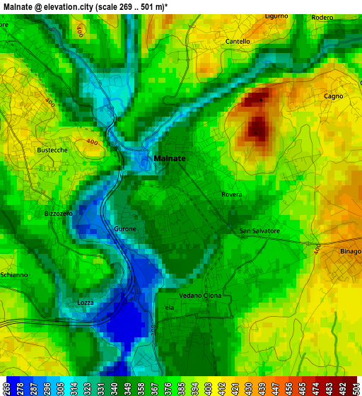
Below is the Elevation map of Malnate, which displays elevation range with different colors. Scale of the first map is from 269 to 501 m (883 to 1644 ft) with average elevation of 372.1 meters (=1221 ft) [note 1]
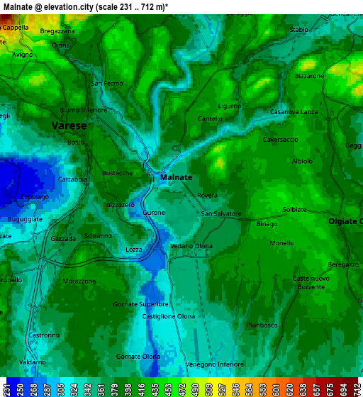
These maps also provides idea of topography and contour of this city, they are displayed at different zoom levels. More info about maps, scale and edge coordinates you can find below images.
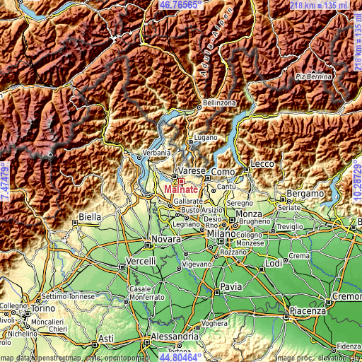
| \ | Map #1 | Map #2 | Topo.Map |
| Scale [m] | 269..501 m | 231..712 m | × |
| Scale [ft] | 883..1644 ft | 758..2336 ft | × |
| Average | 372.1 m = 1221 ft | 378.6 m = 1242 ft | × |
| Width | 6.81 km = 4.2 mi | 13.63 km = 8.5 mi | 218 km = 135.5 mi |
| Height | 6.81 km = 4.2 mi | 13.63 km = 8.5 mi | 218 km = 135.5 mi |
| ↑Max Latitude | 45.824402° | 45.855017° | 46.76565° |
| Latitude at center | 45.79377° | 45.79377° | 45.79377° |
| ↓Min Latitude | 45.763121° | 45.732455° | 44.80464° |
| ← Min Longitude | 8.837095° | 8.793149° | 7.47479° |
| Longitude center | 8.88104° | 8.88104° | 8.88104° |
| →Max Longitude | 8.924985° | 8.968931° | 10.28729° |
Nearby cities:
Cities around Malnate sort by population:
• Castiglione Olona elevation 317 m
4.6 km,  187°
187°
• Vedano Olona 359 m
2.1 km,  165°
165°
• Venegono Superiore 343 m
4.8 km,  164°
164°
• Binago 431 m
3.5 km,  111°
111°
• Gazzada Schianno 382 m
4 km,  247°
247°
• Cantello 408 m
3.4 km,  19°
19°
• Albiolo 426 m
4.7 km,  73°
73°
• Valmorea 409 m
4.5 km,  58°
58°
• Cagno 414 m
3.4 km, 55°
• Solbiate 451 m
4.1 km,  96°
96°
• Lozza 337 m
2.7 km,  221°
221°
• Rodero 407 m
4.3 km,  38°
38°
Multilingual:
 En español:
Malnate elevación 360 m.
 En France:
Malnate élévation 360 m.


Sources and notes:
- [note 1] Map square and city borders are not equal. Map elevation data is calculated only from area inside that square.
- [src 1] Elevation data from geonames database provided with same terms of usage.
- [src 2] The elevation map of Malnate is generated using elevation data from NASA's 3 arcsec (90m) resolution SRTM data.
- [src 3] Base (background) map © OpenStreetMap contributors tiles are generated by Geofabrik and OpenTopoMap.
Copyright & License:
This Malnate Elevation Map is licensed under CC BY-SA. You may reuse any part from this page, if you give a proper credit by linking to this URL:
 More info on terms of use page.