Manta elevation
Manta (Piedmont, Provincia di Cuneo), Italy elevation is 398 meters and Manta elevation in feet is 1306 ft above sea level [src 1]. Manta is a seat of a third-order administrative division (feature code) with elevation that is 76 meters (249 ft) bigger than average city elevation in Italy.
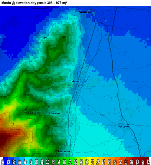
Below is the Elevation map of Manta, which displays elevation range with different colors. Scale of the first map is from 303 to 977 m (994 to 3205 ft) with average elevation of 432.7 meters (=1420 ft) [note 1]
These maps also provides idea of topography and contour of this city, they are displayed at different zoom levels. More info about maps, scale and edge coordinates you can find below images.
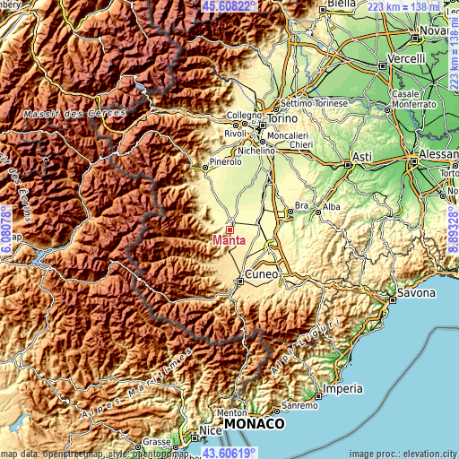
| \ | Map #1 | Topo.Map |
| Scale [m] | 303..977 m | × |
| Scale [ft] | 994..3205 ft | × |
| Average | 432.7 m = 1420 ft | × |
| Width | 6.96 km = 4.3 mi | 222.6 km = 138.3 mi |
| Height | 6.96 km = 4.3 mi | 222.6 km = 138.3 mi |
| ↑Max Latitude | 44.647103° | 45.60822° |
| Latitude at center | 44.61583° | 44.61583° |
| ↓Min Latitude | 44.58454° | 43.60619° |
| ← Min Longitude | 7.443085° | 6.08078° |
| Longitude center | 7.48703° | 7.48703° |
| →Max Longitude | 7.530975° | 8.89328° |
Nearby cities:
Cities around Manta sort by population:
• Saluzzo elevation 348 m
3.5 km,  7°
7°
• Verzuolo 431 m
2.6 km,  189°
189°
• Costiglione Saluzzo 457 m
5.7 km,  181°
181°
• Piasco 496 m
7 km,  209°
209°
• Revello 353 m
8.8 km,  299°
299°
• Villafalletto 431 m
8.8 km,  151°
151°
• Lagnasco 352 m
5.5 km,  79°
79°
• Rossana 524 m
9 km, 208°
• Pagno 374 m
4.9 km,  264°
264°
• Castellar 354 m
4 km,  278°
278°
• Brondello 463 m
6.6 km, 255°
• Isasca 667 m
8.9 km,  249°
249°
Multilingual:
 En español:
Manta elevación 398 m.
 En France:
Manta élévation 398 m.


Sources and notes:
- [note 1] Map square and city borders are not equal. Map elevation data is calculated only from area inside that square.
- [src 1] Elevation data from geonames database provided with same terms of usage.
- [src 2] The elevation map of Manta is generated using elevation data from NASA's 3 arcsec (90m) resolution SRTM data.
- [src 3] Base (background) map © OpenStreetMap contributors tiles are generated by Geofabrik and OpenTopoMap.
Copyright & License:
This Manta Elevation Map is licensed under CC BY-SA. You may reuse any part from this page, if you give a proper credit by linking to this URL:
 More info on terms of use page.