Rossana elevation
Rossana (Piedmont, Provincia di Cuneo), Italy elevation is 524 meters and Rossana elevation in feet is 1719 ft above sea level [src 1]. Rossana is a seat of a third-order administrative division (feature code) with elevation that is 202 meters (663 ft) bigger than average city elevation in Italy.
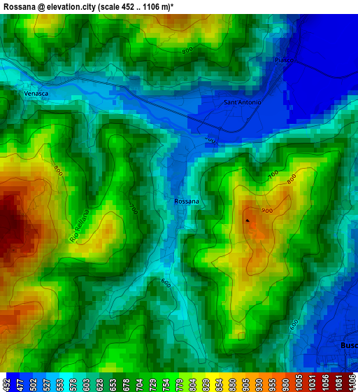
Below is the Elevation map of Rossana, which displays elevation range with different colors. Scale of the first map is from 452 to 1106 m (1483 to 3629 ft) with average elevation of 672.1 meters (=2205 ft) [note 1]
These maps also provides idea of topography and contour of this city, they are displayed at different zoom levels. More info about maps, scale and edge coordinates you can find below images.
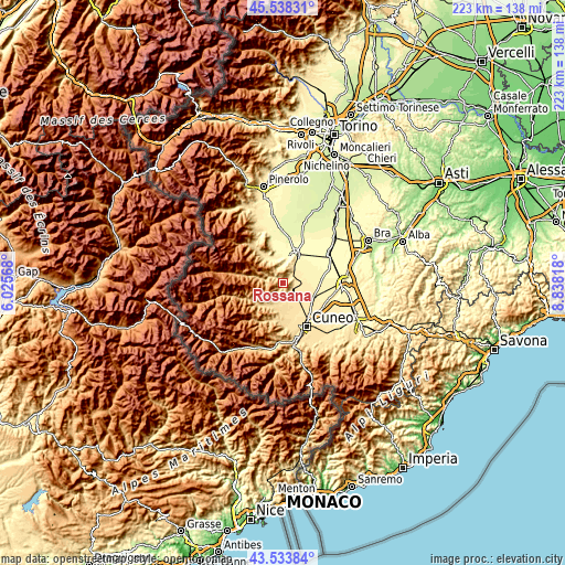
| \ | Map #1 | Topo.Map |
| Scale [m] | 452..1106 m | × |
| Scale [ft] | 1483..3629 ft | × |
| Average | 672.1 m = 2205 ft | × |
| Width | 6.96 km = 4.3 mi | 222.9 km = 138.5 mi |
| Height | 6.96 km = 4.3 mi | 222.9 km = 138.5 mi |
| ↑Max Latitude | 44.576012° | 45.53831° |
| Latitude at center | 44.5447° | 44.5447° |
| ↓Min Latitude | 44.513372° | 43.53384° |
| ← Min Longitude | 7.387985° | 6.02568° |
| Longitude center | 7.43193° | 7.43193° |
| →Max Longitude | 7.475875° | 8.83818° |
Nearby cities:
Cities around Rossana sort by population:
• Busca elevation 499 m
4.7 km,  131°
131°
• Verzuolo 431 m
6.6 km,  36°
36°
• Costiglione Saluzzo 457 m
4.8 km,  62°
62°
• Piasco 496 m
2.1 km,  28°
28°
• Venasca 556 m
3.3 km,  303°
303°
• Brossasco 587 m
5.9 km, 295°
• Villar San Costanzo 620 m
7.7 km,  210°
210°
• Pagno 374 m
7.5 km,  356°
356°
• Castellar 354 m
8.5 km,  2°
2°
• Brondello 463 m
6.6 km,  341°
341°
• Isasca 667 m
6.2 km,  320°
320°
• Valmala 833 m
6.8 km,  269°
269°
Multilingual:
 En español:
Rossana elevación 524 m.
 En France:
Rossana élévation 524 m.


Sources and notes:
- [note 1] Map square and city borders are not equal. Map elevation data is calculated only from area inside that square.
- [src 1] Elevation data from geonames database provided with same terms of usage.
- [src 2] The elevation map of Rossana is generated using elevation data from NASA's 3 arcsec (90m) resolution SRTM data.
- [src 3] Base (background) map © OpenStreetMap contributors tiles are generated by Geofabrik and OpenTopoMap.
Copyright & License:
This Rossana Elevation Map is licensed under CC BY-SA. You may reuse any part from this page, if you give a proper credit by linking to this URL:
 More info on terms of use page.