Mel elevation
Mel (Veneto, Provincia di Belluno), Italy elevation is 319 meters and Mel elevation in feet is 1047 ft above sea level [src 1]. Mel is a seat of a third-order administrative division (feature code) with elevation that is 3 meters (10 ft) smaller than average city elevation in Italy.
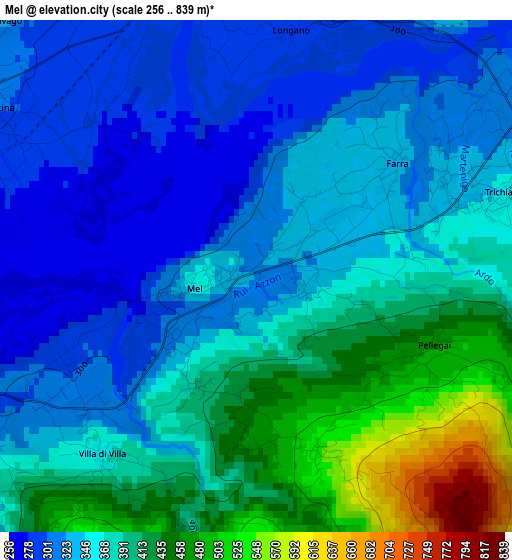
Below is the Elevation map of Mel, which displays elevation range with different colors. Scale of the first map is from 256 to 839 m (840 to 2753 ft) with average elevation of 368.7 meters (=1210 ft) [note 1]
These maps also provides idea of topography and contour of this city, they are displayed at different zoom levels. More info about maps, scale and edge coordinates you can find below images.
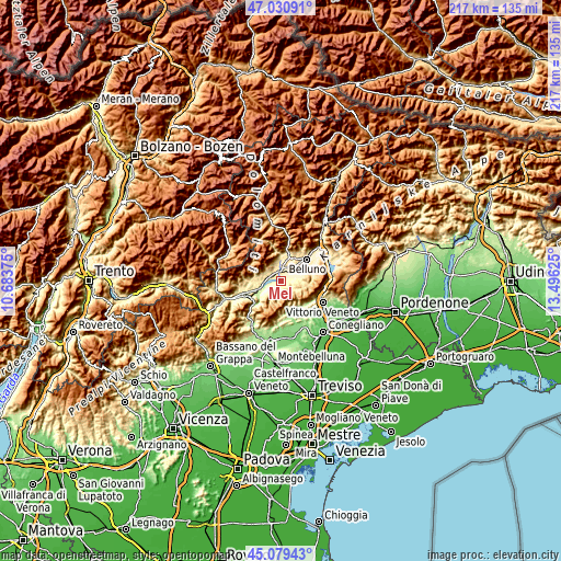
| \ | Map #1 | Topo.Map |
| Scale [m] | 256..839 m | × |
| Scale [ft] | 840..2753 ft | × |
| Average | 368.7 m = 1210 ft | × |
| Width | 6.78 km = 4.2 mi | 217 km = 134.8 mi |
| Height | 6.78 km = 4.2 mi | 217 km = 134.8 mi |
| ↑Max Latitude | 46.094273° | 47.03091° |
| Latitude at center | 46.06379° | 46.06379° |
| ↓Min Latitude | 46.03329° | 45.07943° |
| ← Min Longitude | 12.046055° | 10.68375° |
| Longitude center | 12.09° | 12.09° |
| →Max Longitude | 12.133945° | 13.49625° |
Nearby cities:
Cities around Mel sort by population:
• Sedico elevation 311 m
4.7 km,  3°
3°
• Santa Giustina 305 m
4.4 km,  295°
295°
• Limana 361 m
8.4 km,  61°
61°
• Castion 421 m
12.9 km, 60°
• Trichiana 333 m
4.4 km, 63°
• Follina 195 m
12.5 km,  169°
169°
• Lentiai 260 m
5.8 km,  248°
248°
• Cison di Valmarino 245 m
11.5 km,  159°
159°
• Villabruna-Umin 361 m
12.6 km,  266°
266°
• Cesiomaggiore 468 m
8.5 km,  287°
287°
• Sospirolo 453 m
8.7 km,  351°
351°
• San Gregorio nelle Alpi 545 m
6.6 km,  312°
312°
Multilingual:
 En español:
Mel elevación 319 m.
 En France:
Mel élévation 319 m.


Sources and notes:
- [note 1] Map square and city borders are not equal. Map elevation data is calculated only from area inside that square.
- [src 1] Elevation data from geonames database provided with same terms of usage.
- [src 2] The elevation map of Mel is generated using elevation data from NASA's 3 arcsec (90m) resolution SRTM data.
- [src 3] Base (background) map © OpenStreetMap contributors tiles are generated by Geofabrik and OpenTopoMap.
Copyright & License:
This Mel Elevation Map is licensed under CC BY-SA. You may reuse any part from this page, if you give a proper credit by linking to this URL:
 More info on terms of use page.