Villabruna-Umin elevation
Villabruna-Umin (Veneto, Provincia di Belluno), Italy elevation is 361 meters and Villabruna-Umin elevation in feet is 1184 ft above sea level [src 1]. Villabruna-Umin is a populated place (feature code) with elevation that is 39 meters (128 ft) bigger than average city elevation in Italy.
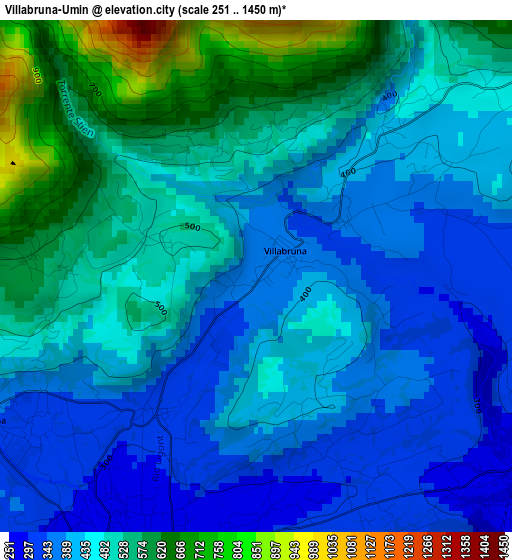
Below is the Elevation map of Villabruna-Umin, which displays elevation range with different colors. Scale of the first map is from 251 to 1450 m (823 to 4757 ft) with average elevation of 461.7 meters (=1515 ft) [note 1]
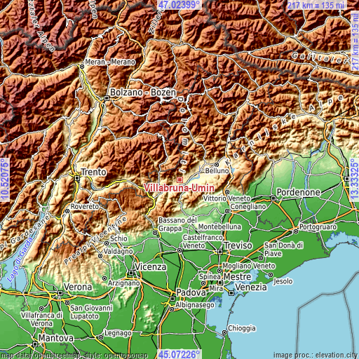
These maps also provides idea of topography and contour of this city, they are displayed at different zoom levels. More info about maps, scale and edge coordinates you can find below images.
| \ | Map #1 | Topo.Map |
| Scale [m] | 251..1450 m | × |
| Scale [ft] | 823..4757 ft | × |
| Average | 461.7 m = 1515 ft | × |
| Width | 6.78 km = 4.2 mi | 217 km = 134.8 mi |
| Height | 6.78 km = 4.2 mi | 217 km = 134.8 mi |
| ↑Max Latitude | 46.087237° | 47.02399° |
| Latitude at center | 46.05675° | 46.05675° |
| ↓Min Latitude | 46.026246° | 45.07226° |
| ← Min Longitude | 11.883055° | 10.52075° |
| Longitude center | 11.927° | 11.927° |
| →Max Longitude | 11.970945° | 13.33325° |
Nearby cities:
Cities around Villabruna-Umin sort by population:
• Feltre elevation 275 m
4.5 km,  207°
207°
• Santa Giustina 305 m
9 km,  72°
72°
• Pedavena 337 m
3.9 km,  240°
240°
• Fonzaso 322 m
10.9 km,  245°
245°
• Mel 319 m
12.6 km,  86°
86°
• Sovramonte 618 m
10.8 km,  271°
271°
• Seren del Grappa 316 m
8.7 km,  218°
218°
• Lentiai 260 m
7.3 km,  100°
100°
• Cesiomaggiore 468 m
5.6 km,  53°
53°
• Vas 216 m
13.2 km,  177°
177°
• San Gregorio nelle Alpi 545 m
9.3 km,  55°
55°
• Servo 618 m
10.8 km, 270°
Multilingual:
 En español:
Villabruna-Umin elevación 361 m.
 En France:
Villabruna-Umin élévation 361 m.
 Auf Deutsch:
Villabruna-Umin höhe über dem Meeresspiegel ist 361 m.

Sources and notes:
- [note 1] Map square and city borders are not equal. Map elevation data is calculated only from area inside that square.
- [src 1] Elevation data from geonames database provided with same terms of usage.
- [src 2] The elevation map of Villabruna-Umin is generated using elevation data from NASA's 3 arcsec (90m) resolution SRTM data.
- [src 3] Base (background) map © OpenStreetMap contributors tiles are generated by Geofabrik and OpenTopoMap.
Copyright & License:
This Villabruna-Umin Elevation Map is licensed under CC BY-SA. You may reuse any part from this page, if you give a proper credit by linking to this URL:
 More info on terms of use page.