Moneglia elevation
Moneglia (Liguria, Provincia di Genova), Italy elevation is 20 meters and Moneglia elevation in feet is 66 ft above sea level [src 1]. Moneglia is a seat of a third-order administrative division (feature code) with elevation that is 302 meters (991 ft) smaller than average city elevation in Italy.
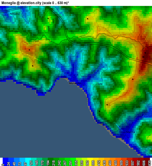
Below is the Elevation map of Moneglia, which displays elevation range with different colors. Scale of the first map is from 0 to 630 m (0 to 2067 ft) with average elevation of 233.4 meters (=766 ft) [note 1]
These maps also provides idea of topography and contour of this city, they are displayed at different zoom levels. More info about maps, scale and edge coordinates you can find below images.
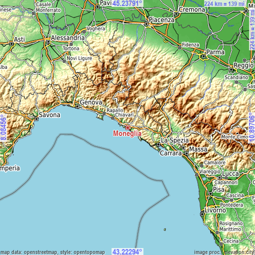
| \ | Map #1 | Topo.Map |
| Scale [m] | 0..630 m | × |
| Scale [ft] | 0..2067 ft | × |
| Average | 233.4 m = 766 ft | × |
| Width | 7 km = 4.3 mi | 224 km = 139.2 mi |
| Height | 7 km = 4.3 mi | 224 km = 139.2 mi |
| ↑Max Latitude | 44.270526° | 45.23791° |
| Latitude at center | 44.23905° | 44.23905° |
| ↓Min Latitude | 44.207558° | 43.22294° |
| ← Min Longitude | 9.446865° | 8.08456° |
| Longitude center | 9.49081° | 9.49081° |
| →Max Longitude | 9.534755° | 10.89706° |
Nearby cities:
Cities around Moneglia sort by population:
• Sestri Levante elevation 5 m
8.4 km,  296°
296°
• Lavagna 38 m
13.2 km, 304°
• Casarza Ligure 24 m
5 km,  316°
316°
• Levanto 13 m
12.4 km,  125°
125°
• Framura 160 m
6 km,  123°
123°
• Deiva Marina 13 m
3.2 km, 132°
• Cogorno 215 m
13.2 km,  313°
313°
• Bonassola 12 m
9.7 km, 129°
• Carrodano 216 m
13.1 km,  88°
88°
• Castiglione 273 m
4.5 km,  27°
27°
• Carro 391 m
10.1 km,  68°
68°
• Maissana 556 m
11.4 km,  18°
18°
Multilingual:
 En español:
Moneglia elevación 20 m.
 En France:
Moneglia élévation 20 m.


Sources and notes:
- [note 1] Map square and city borders are not equal. Map elevation data is calculated only from area inside that square.
- [src 1] Elevation data from geonames database provided with same terms of usage.
- [src 2] The elevation map of Moneglia is generated using elevation data from NASA's 3 arcsec (90m) resolution SRTM data.
- [src 3] Base (background) map © OpenStreetMap contributors tiles are generated by Geofabrik and OpenTopoMap.
Copyright & License:
This Moneglia Elevation Map is licensed under CC BY-SA. You may reuse any part from this page, if you give a proper credit by linking to this URL:
 More info on terms of use page.