Montelparo elevation
Montelparo (The Marches, Province of Fermo), Italy elevation is 543 meters and Montelparo elevation in feet is 1781 ft above sea level [src 1]. Montelparo is a seat of a third-order administrative division (feature code) with elevation that is 221 meters (725 ft) bigger than average city elevation in Italy.
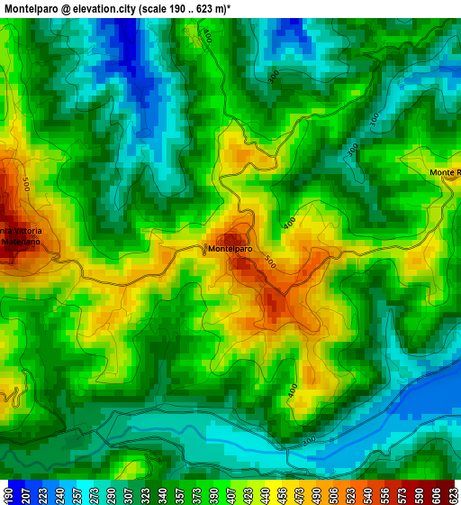
Below is the Elevation map of Montelparo, which displays elevation range with different colors. Scale of the first map is from 190 to 623 m (623 to 2044 ft) with average elevation of 362.6 meters (=1190 ft) [note 1]
These maps also provides idea of topography and contour of this city, they are displayed at different zoom levels. More info about maps, scale and edge coordinates you can find below images.
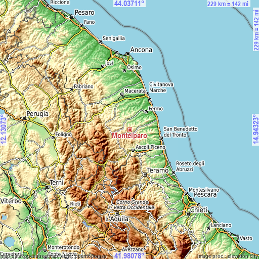
| \ | Map #1 | Topo.Map |
| Scale [m] | 190..623 m | × |
| Scale [ft] | 623..2044 ft | × |
| Average | 362.6 m = 1190 ft | × |
| Width | 7.15 km = 4.4 mi | 228.6 km = 142 mi |
| Height | 7.15 km = 4.4 mi | 228.6 km = 142 mi |
| ↑Max Latitude | 43.049672° | 44.03711° |
| Latitude at center | 43.01755° | 43.01755° |
| ↓Min Latitude | 42.985411° | 41.98078° |
| ← Min Longitude | 13.493035° | 12.13073° |
| Longitude center | 13.53698° | 13.53698° |
| →Max Longitude | 13.580925° | 14.94323° |
Nearby cities:
Cities around Montelparo sort by population:
• Monsampietro Morico elevation 273 m
5.8 km,  15°
15°
• Force 662 m
7.5 km,  212°
212°
• Montalto delle Marche 505 m
6.6 km,  118°
118°
• San Vittoria in Matenano 600 m
3.3 km,  274°
274°
• Montefalcone Appennino 766 m
7.2 km,  244°
244°
• Montottone 260 m
6.6 km,  41°
41°
• Monte Rinaldo 457 m
3.8 km,  71°
71°
• Smerillo 787 m
7.6 km,  259°
259°
• Rotella 390 m
7.2 km,  166°
166°
• Ortezzano 306 m
5.7 km,  75°
75°
• Montedinove 528 m
6.6 km,  139°
139°
• Monteleone di Fermo 421 m
3.4 km,  349°
349°
Multilingual:
 En español:
Montelparo elevación 543 m.
 En France:
Montelparo élévation 543 m.
 Auf Deutsch:
Montelparo höhe über dem Meeresspiegel ist 543 m.

Sources and notes:
- [note 1] Map square and city borders are not equal. Map elevation data is calculated only from area inside that square.
- [src 1] Elevation data from geonames database provided with same terms of usage.
- [src 2] The elevation map of Montelparo is generated using elevation data from NASA's 3 arcsec (90m) resolution SRTM data.
- [src 3] Base (background) map © OpenStreetMap contributors tiles are generated by Geofabrik and OpenTopoMap.
Copyright & License:
This Montelparo Elevation Map is licensed under CC BY-SA. You may reuse any part from this page, if you give a proper credit by linking to this URL:
 More info on terms of use page.