Montiglio elevation
Montiglio (Piedmont, Provincia di Asti), Italy elevation is 264 meters and Montiglio elevation in feet is 866 ft above sea level [src 1]. Montiglio is a seat of a third-order administrative division (feature code) with elevation that is 58 meters (190 ft) smaller than average city elevation in Italy.
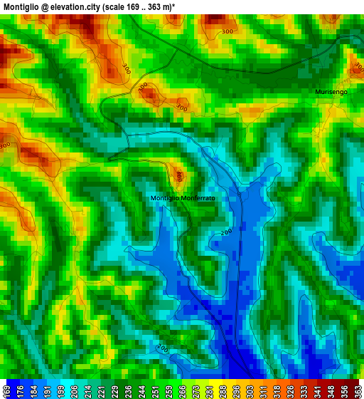
Below is the Elevation map of Montiglio, which displays elevation range with different colors. Scale of the first map is from 169 to 363 m (554 to 1191 ft) with average elevation of 241.4 meters (=792 ft) [note 1]
These maps also provides idea of topography and contour of this city, they are displayed at different zoom levels. More info about maps, scale and edge coordinates you can find below images.
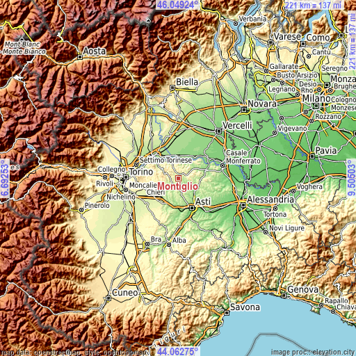
| \ | Map #1 | Topo.Map |
| Scale [m] | 169..363 m | × |
| Scale [ft] | 554..1191 ft | × |
| Average | 241.4 m = 792 ft | × |
| Width | 6.9 km = 4.3 mi | 220.9 km = 137.3 mi |
| Height | 6.9 km = 4.3 mi | 220.9 km = 137.3 mi |
| ↑Max Latitude | 45.095651° | 46.04924° |
| Latitude at center | 45.06462° | 45.06462° |
| ↓Min Latitude | 45.033573° | 44.06275° |
| ← Min Longitude | 8.054835° | 6.69253° |
| Longitude center | 8.09878° | 8.09878° |
| →Max Longitude | 8.142725° | 9.50503° |
Nearby cities:
Cities around Montiglio sort by population:
• Montechiaro d'Asti elevation 270 m
6.5 km,  170°
170°
• Cocconato 446 m
5.2 km,  297°
297°
• Murisengo 273 m
3.5 km,  56°
56°
• Passerano Marmorito 292 m
6.4 km,  261°
261°
• Brozolo 364 m
6.2 km,  340°
340°
• Piovà Massaia 317 m
4 km,  254°
254°
• Cunico 244 m
2.7 km,  185°
185°
• Piea 253 m
4.7 km,  207°
207°
• Cortanze 272 m
5.7 km, 187°
• Villadeati 375 m
5.5 km,  81°
81°
• Cerreto d'Asti 291 m
5.2 km, 254°
• Robella 400 m
4.1 km,  3°
3°
Multilingual:
 En español:
Montiglio elevación 264 m.
 En France:
Montiglio élévation 264 m.
 Auf Deutsch:
Montiglio höhe über dem Meeresspiegel ist 264 m.

Sources and notes:
- [note 1] Map square and city borders are not equal. Map elevation data is calculated only from area inside that square.
- [src 1] Elevation data from geonames database provided with same terms of usage.
- [src 2] The elevation map of Montiglio is generated using elevation data from NASA's 3 arcsec (90m) resolution SRTM data.
- [src 3] Base (background) map © OpenStreetMap contributors tiles are generated by Geofabrik and OpenTopoMap.
Copyright & License:
This Montiglio Elevation Map is licensed under CC BY-SA. You may reuse any part from this page, if you give a proper credit by linking to this URL:
 More info on terms of use page.