Piea elevation
Piea (Piedmont, Provincia di Asti), Italy elevation is 253 meters and Piea elevation in feet is 830 ft above sea level [src 1]. Piea is a seat of a third-order administrative division (feature code) with elevation that is 69 meters (226 ft) smaller than average city elevation in Italy.
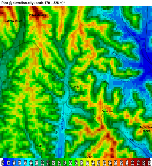
Below is the Elevation map of Piea, which displays elevation range with different colors. Scale of the first map is from 170 to 328 m (558 to 1076 ft) with average elevation of 233.4 meters (=766 ft) [note 1]
These maps also provides idea of topography and contour of this city, they are displayed at different zoom levels. More info about maps, scale and edge coordinates you can find below images.
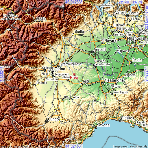
| \ | Map #1 | Topo.Map |
| Scale [m] | 170..328 m | × |
| Scale [ft] | 558..1076 ft | × |
| Average | 233.4 m = 766 ft | × |
| Width | 6.91 km = 4.3 mi | 221 km = 137.3 mi |
| Height | 6.91 km = 4.3 mi | 221 km = 137.3 mi |
| ↑Max Latitude | 45.058111° | 46.01233° |
| Latitude at center | 45.02706° | 45.02706° |
| ↓Min Latitude | 44.995992° | 44.02453° |
| ← Min Longitude | 8.027515° | 6.66521° |
| Longitude center | 8.07146° | 8.07146° |
| →Max Longitude | 8.115405° | 9.47771° |
Nearby cities:
Cities around Piea sort by population:
• Montechiaro d'Asti elevation 270 m
3.9 km,  124°
124°
• Camerano Casasco 297 m
4.2 km,  158°
158°
• Montiglio 264 m
4.7 km,  27°
27°
• Passerano Marmorito 292 m
5.2 km,  307°
307°
• Piovà Massaia 317 m
3.5 km,  331°
331°
• Cunico 244 m
2.4 km,  51°
51°
• Camerano 295 m
4.2 km, 160°
• Cortanze 272 m
2 km,  136°
136°
• Viale 245 m
3.4 km,  209°
209°
• Cerreto d'Asti 291 m
4 km, 314°
• Cortazzone 201 m
5.4 km,  188°
188°
• Soglio 279 m
3.5 km,  170°
170°
Multilingual:
 En español:
Piea elevación 253 m.
 En France:
Piea élévation 253 m.


Sources and notes:
- [note 1] Map square and city borders are not equal. Map elevation data is calculated only from area inside that square.
- [src 1] Elevation data from geonames database provided with same terms of usage.
- [src 2] The elevation map of Piea is generated using elevation data from NASA's 3 arcsec (90m) resolution SRTM data.
- [src 3] Base (background) map © OpenStreetMap contributors tiles are generated by Geofabrik and OpenTopoMap.
Copyright & License:
This Piea Elevation Map is licensed under CC BY-SA. You may reuse any part from this page, if you give a proper credit by linking to this URL:
 More info on terms of use page.