Nemi elevation
Nemi (Latium, Città metropolitana di Roma Capitale), Italy elevation is 619 meters and Nemi elevation in feet is 2031 ft above sea level [src 1]. Nemi is a seat of a third-order administrative division (feature code) with elevation that is 297 meters (974 ft) bigger than average city elevation in Italy.
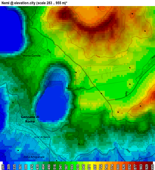
Below is the Elevation map of Nemi, which displays elevation range with different colors. Scale of the first map is from 283 to 955 m (928 to 3133 ft) with average elevation of 546.3 meters (=1792 ft) [note 1]
These maps also provides idea of topography and contour of this city, they are displayed at different zoom levels. More info about maps, scale and edge coordinates you can find below images.
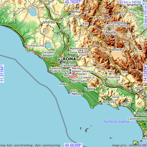
| \ | Map #1 | Topo.Map |
| Scale [m] | 283..955 m | × |
| Scale [ft] | 928..3133 ft | × |
| Average | 546.3 m = 1792 ft | × |
| Width | 7.29 km = 4.5 mi | 233.4 km = 145 mi |
| Height | 7.29 km = 4.5 mi | 233.4 km = 145 mi |
| ↑Max Latitude | 41.754642° | 42.76287° |
| Latitude at center | 41.72185° | 41.72185° |
| ↓Min Latitude | 41.689042° | 40.66369° |
| ← Min Longitude | 12.674145° | 11.31184° |
| Longitude center | 12.71809° | 12.71809° |
| →Max Longitude | 12.762035° | 14.12434° |
Nearby cities:
Cities around Nemi sort by population:
• Velletri elevation 359 m
6.4 km,  129°
129°
• Marino 360 m
7.2 km,  317°
317°
• Albano Laziale 382 m
4.9 km,  277°
277°
• Genzano di Roma 442 m
2.9 km,  235°
235°
• Grottaferrata 353 m
8.2 km,  331°
331°
• Ariccia 415 m
3.8 km,  267°
267°
• Rocca di Papa 567 m
5.1 km,  344°
344°
• Cecchina 266 m
6.1 km,  248°
248°
• Rocca Priora 607 m
6.3 km,  38°
38°
• Lanuvio 276 m
5.8 km,  200°
200°
• Pavona 199 m
8.5 km, 273°
• Castel Gandolfo 384 m
6.4 km,  297°
297°
Multilingual:
 En español:
Nemi elevación 619 m.
 En France:
Nemi élévation 619 m.


Sources and notes:
- [note 1] Map square and city borders are not equal. Map elevation data is calculated only from area inside that square.
- [src 1] Elevation data from geonames database provided with same terms of usage.
- [src 2] The elevation map of Nemi is generated using elevation data from NASA's 3 arcsec (90m) resolution SRTM data.
- [src 3] Base (background) map © OpenStreetMap contributors tiles are generated by Geofabrik and OpenTopoMap.
Copyright & License:
This Nemi Elevation Map is licensed under CC BY-SA. You may reuse any part from this page, if you give a proper credit by linking to this URL:
 More info on terms of use page.