Grottaferrata elevation
Grottaferrata (Latium, Città metropolitana di Roma Capitale), Italy elevation is 353 meters and Grottaferrata elevation in feet is 1158 ft above sea level [src 1]. Grottaferrata is a seat of a third-order administrative division (feature code) with elevation that is 31 meters (102 ft) bigger than average city elevation in Italy.
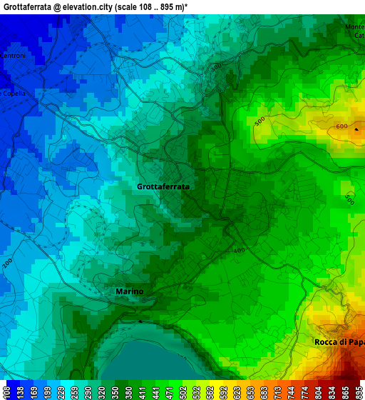
Below is the Elevation map of Grottaferrata, which displays elevation range with different colors. Scale of the first map is from 108 to 895 m (354 to 2936 ft) with average elevation of 345.6 meters (=1134 ft) [note 1]
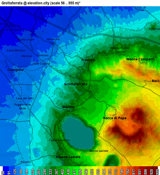
These maps also provides idea of topography and contour of this city, they are displayed at different zoom levels. More info about maps, scale and edge coordinates you can find below images.
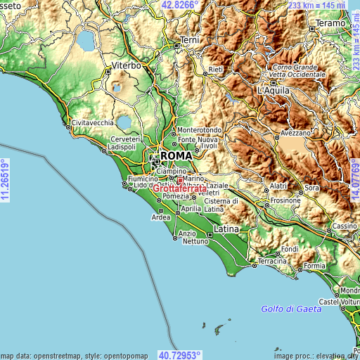
| \ | Map #1 | Map #2 | Topo.Map |
| Scale [m] | 108..895 m | 56..955 m | × |
| Scale [ft] | 354..2936 ft | 184..3133 ft | × |
| Average | 345.6 m = 1134 ft | 325.1 m = 1067 ft | × |
| Width | 7.29 km = 4.5 mi | 14.57 km = 9.1 mi | 233.2 km = 144.9 mi |
| Height | 7.29 km = 4.5 mi | 14.57 km = 9.1 mi | 233.2 km = 144.9 mi |
| ↑Max Latitude | 41.819399° | 41.852141° | 42.8266° |
| Latitude at center | 41.78664° | 41.78664° | 41.78664° |
| ↓Min Latitude | 41.753865° | 41.721072° | 40.72953° |
| ← Min Longitude | 12.627495° | 12.583549° | 11.26519° |
| Longitude center | 12.67144° | 12.67144° | 12.67144° |
| →Max Longitude | 12.715385° | 12.759331° | 14.07769° |
Nearby cities:
Cities around Grottaferrata sort by population:
• Marino elevation 360 m
2.1 km,  208°
208°
• Ciampino 127 m
6 km,  285°
285°
• Albano Laziale 382 m
6.7 km,  188°
188°
• Frascati 326 m
2.6 km,  14°
14°
• Ariccia 415 m
7.3 km,  179°
179°
• Rocca di Papa 567 m
3.4 km,  132°
132°
• Rocca Priora 607 m
8.2 km,  106°
106°
• Monte Porzio Catone 442 m
4.8 km,  47°
47°
• Montecompatri 573 m
6 km,  65°
65°
• Pavona 199 m
8.1 km, 214°
• Castel Gandolfo 384 m
4.6 km,  203°
203°
• Armetta 328 m
3.2 km,  25°
25°
Multilingual:
 En español:
Grottaferrata elevación 353 m.
 En France:
Grottaferrata élévation 353 m.
 Auf Deutsch:
Grottaferrata höhe über dem Meeresspiegel ist 353 m.

Sources and notes:
- [note 1] Map square and city borders are not equal. Map elevation data is calculated only from area inside that square.
- [src 1] Elevation data from geonames database provided with same terms of usage.
- [src 2] The elevation map of Grottaferrata is generated using elevation data from NASA's 3 arcsec (90m) resolution SRTM data.
- [src 3] Base (background) map © OpenStreetMap contributors tiles are generated by Geofabrik and OpenTopoMap.
Copyright & License:
This Grottaferrata Elevation Map is licensed under CC BY-SA. You may reuse any part from this page, if you give a proper credit by linking to this URL:
 More info on terms of use page.