Novate Mezzola elevation
Novate Mezzola (Lombardy, Provincia di Sondrio), Italy elevation is 225 meters and Novate Mezzola elevation in feet is 738 ft above sea level [src 1]. Novate Mezzola is a seat of a third-order administrative division (feature code) with elevation that is 97 meters (318 ft) smaller than average city elevation in Italy.
Below is the Elevation map of Novate Mezzola, which displays elevation range with different colors. Scale of the first map is from 187 to 1900 m (614 to 6234 ft) with average elevation of 627.7 meters (=2059 ft) [note 1]
These maps also provides idea of topography and contour of this city, they are displayed at different zoom levels. More info about maps, scale and edge coordinates you can find below images.
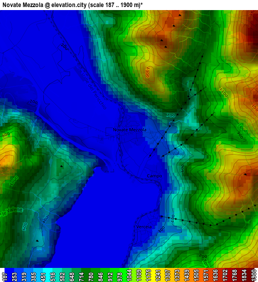
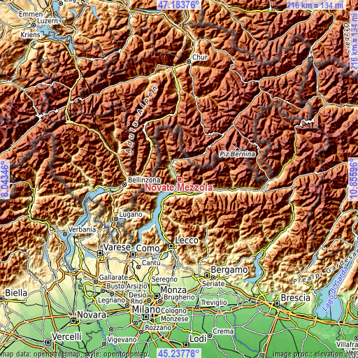
| \ | Map #1 | Topo.Map |
| Scale [m] | 187..1900 m | × |
| Scale [ft] | 614..6234 ft | × |
| Average | 627.7 m = 2059 ft | × |
| Width | 6.76 km = 4.2 mi | 216.4 km = 134.5 mi |
| Height | 6.76 km = 4.2 mi | 216.4 km = 134.5 mi |
| ↑Max Latitude | 46.249787° | 47.18376° |
| Latitude at center | 46.21939° | 46.21939° |
| ↓Min Latitude | 46.188976° | 45.23778° |
| ← Min Longitude | 9.405765° | 8.04346° |
| Longitude center | 9.44971° | 9.44971° |
| →Max Longitude | 9.493655° | 10.85596° |
Nearby cities:
Cities around Novate Mezzola sort by population:
• Dubino elevation 202 m
6 km,  194°
194°
• Samolaco 229 m
5 km,  300°
300°
• San Cassiano 229 m
7.6 km,  327°
327°
• Verceia 228 m
2.3 km,  170°
170°
• Era 218 m
5 km, 303°
• Gera Lario 224 m
8.4 km,  229°
229°
• Mantello 216 m
8 km,  157°
157°
• Sorico 207 m
7.3 km,  224°
224°
• Cino 492 m
7.3 km, 157°
• Montemezzo 563 m
7.6 km, 233°
• Aurogna 391 m
9 km, 233°
• Cercino 526 m
8.2 km,  146°
146°
Multilingual:
 En español:
Novate Mezzola elevación 225 m.
 En France:
Novate Mezzola élévation 225 m.
 Auf Deutsch:
Novate Mezzola höhe über dem Meeresspiegel ist 225 m.

Sources and notes:
- [note 1] Map square and city borders are not equal. Map elevation data is calculated only from area inside that square.
- [src 1] Elevation data from geonames database provided with same terms of usage.
- [src 2] The elevation map of Novate Mezzola is generated using elevation data from NASA's 3 arcsec (90m) resolution SRTM data.
- [src 3] Base (background) map © OpenStreetMap contributors tiles are generated by Geofabrik and OpenTopoMap.
Copyright & License:
This Novate Mezzola Elevation Map is licensed under CC BY-SA. You may reuse any part from this page, if you give a proper credit by linking to this URL:
 More info on terms of use page.