Offida elevation
Offida (The Marches, Provincia di Ascoli Piceno), Italy elevation is 275 meters and Offida elevation in feet is 902 ft above sea level [src 1]. Offida is a seat of a third-order administrative division (feature code) with elevation that is 47 meters (154 ft) smaller than average city elevation in Italy.
Below is the Elevation map of Offida, which displays elevation range with different colors. Scale of the first map is from 93 to 439 m (305 to 1440 ft) with average elevation of 228.5 meters (=750 ft) [note 1]
These maps also provides idea of topography and contour of this city, they are displayed at different zoom levels. More info about maps, scale and edge coordinates you can find below images.
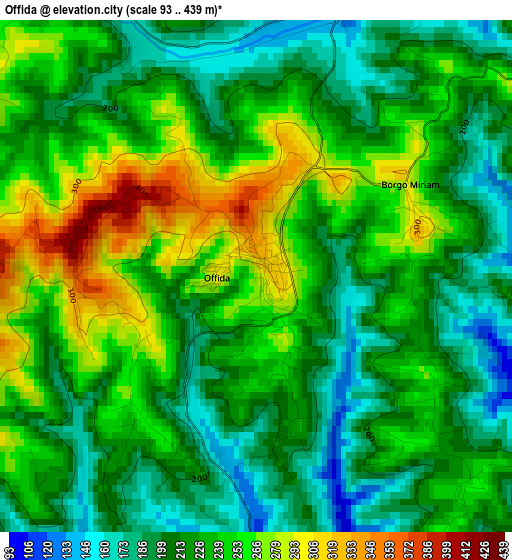
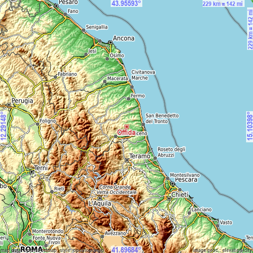
| \ | Map #1 | Topo.Map |
| Scale [m] | 93..439 m | × |
| Scale [ft] | 305..1440 ft | × |
| Average | 228.5 m = 750 ft | × |
| Width | 7.15 km = 4.4 mi | 228.9 km = 142.2 mi |
| Height | 7.15 km = 4.4 mi | 228.9 km = 142.2 mi |
| ↑Max Latitude | 42.967155° | 43.95593° |
| Latitude at center | 42.93499° | 42.93499° |
| ↓Min Latitude | 42.902808° | 41.89684° |
| ← Min Longitude | 13.653785° | 12.29148° |
| Longitude center | 13.69773° | 13.69773° |
| →Max Longitude | 13.741675° | 15.10398° |
Nearby cities:
Cities around Offida sort by population:
• Piattoni-Villa Sant'Antonio elevation 148 m
7.7 km,  171°
171°
• Castel di Lama 81 m
8 km, 167°
• Pagliare 42 m
9.4 km,  141°
141°
• Villa San Giuseppe 60 m
8.3 km,  152°
152°
• Ripatransone 487 m
8.9 km,  35°
35°
• Colli del Tronto 157 m
7.6 km, 147°
• Castignano 442 m
5.9 km,  274°
274°
• Appignano del Tronto 184 m
5 km,  215°
215°
• Spinetoli 190 m
7.4 km,  132°
132°
• Castorano 265 m
4.9 km, 147°
• Monsampolo del Tronto 174 m
8.8 km,  118°
118°
• Cossignano 359 m
5.4 km,  353°
353°
Multilingual:
 En español:
Offida elevación 275 m.
 En France:
Offida élévation 275 m.


Sources and notes:
- [note 1] Map square and city borders are not equal. Map elevation data is calculated only from area inside that square.
- [src 1] Elevation data from geonames database provided with same terms of usage.
- [src 2] The elevation map of Offida is generated using elevation data from NASA's 3 arcsec (90m) resolution SRTM data.
- [src 3] Base (background) map © OpenStreetMap contributors tiles are generated by Geofabrik and OpenTopoMap.
Copyright & License:
This Offida Elevation Map is licensed under CC BY-SA. You may reuse any part from this page, if you give a proper credit by linking to this URL:
 More info on terms of use page.