Ortona elevation
Ortona (Abruzzo, Provincia di Chieti), Italy elevation is 74 meters and Ortona elevation in feet is 243 ft above sea level [src 1]. Ortona is a seat of a third-order administrative division (feature code) with elevation that is 248 meters (814 ft) smaller than average city elevation in Italy.
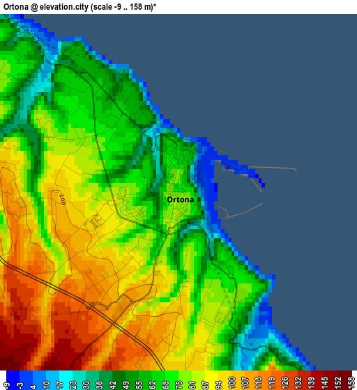
Below is the Elevation map of Ortona, which displays elevation range with different colors. Scale of the first map is from -9 to 158 m (-30 to 518 ft) with average elevation of 77.5 meters (=254 ft) [note 1]
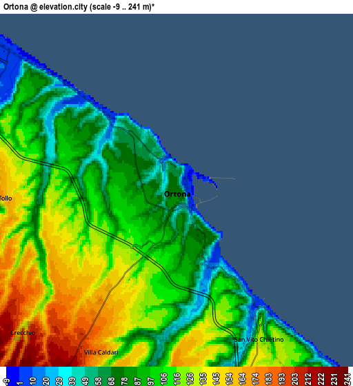
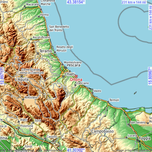
These maps also provides idea of topography and contour of this city, they are displayed at different zoom levels. More info about maps, scale and edge coordinates you can find below images.
| \ | Map #1 | Map #2 | Topo.Map |
| Scale [m] | -9..158 m | -9..241 m | × |
| Scale [ft] | -30..518 ft | -30..791 ft | × |
| Average | 77.5 m = 254 ft | 106.5 m = 349 ft | × |
| Width | 7.22 km = 4.5 mi | 14.44 km = 9 mi | 231.1 km = 143.6 mi |
| Height | 7.22 km = 4.5 mi | 14.44 km = 9 mi | 231.1 km = 143.6 mi |
| ↑Max Latitude | 42.383339° | 42.415791° | 43.38154° |
| Latitude at center | 42.35087° | 42.35087° | 42.35087° |
| ↓Min Latitude | 42.318385° | 42.285882° | 41.30302° |
| ← Min Longitude | 14.359475° | 14.315529° | 12.99717° |
| Longitude center | 14.40342° | 14.40342° | 14.40342° |
| →Max Longitude | 14.447365° | 14.491311° | 15.80967° |
Nearby cities:
Cities around Ortona sort by population:
• Tollo elevation 154 m
6.6 km,  264°
264°
• San Vito Chietino 144 m
7.5 km,  154°
154°
• Miglianico 126 m
9.2 km,  274°
274°
• Frisa 233 m
9.7 km,  193°
193°
• Villa Caldari 185 m
7 km,  209°
209°
• Marina di San Vito 27 m
6.3 km,  143°
143°
• Giuliano Teatino 238 m
11 km,  246°
246°
• Canosa Sannita 239 m
10.1 km,  233°
233°
• Poggiofiorito 298 m
12.7 km, 212°
• Rocca San Giovanni 169 m
12.6 km,  157°
157°
• Treglio 197 m
10 km,  170°
170°
• Crecchio 205 m
8.6 km, 226°
Multilingual:
 En español:
Ortona elevación 74 m.
 En France:
Ortona élévation 74 m.


Sources and notes:
- [note 1] Map square and city borders are not equal. Map elevation data is calculated only from area inside that square.
- [src 1] Elevation data from geonames database provided with same terms of usage.
- [src 2] The elevation map of Ortona is generated using elevation data from NASA's 3 arcsec (90m) resolution SRTM data.
- [src 3] Base (background) map © OpenStreetMap contributors tiles are generated by Geofabrik and OpenTopoMap.
Copyright & License:
This Ortona Elevation Map is licensed under CC BY-SA. You may reuse any part from this page, if you give a proper credit by linking to this URL:
 More info on terms of use page.