Rocca San Giovanni elevation
Rocca San Giovanni (Abruzzo, Provincia di Chieti), Italy elevation is 169 meters and Rocca San Giovanni elevation in feet is 554 ft above sea level [src 1]. Rocca San Giovanni is a seat of a third-order administrative division (feature code) with elevation that is 153 meters (502 ft) smaller than average city elevation in Italy.
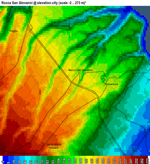
Below is the Elevation map of Rocca San Giovanni, which displays elevation range with different colors. Scale of the first map is from -2 to 273 m (-7 to 896 ft) with average elevation of 137.5 meters (=451 ft) [note 1]
These maps also provides idea of topography and contour of this city, they are displayed at different zoom levels. More info about maps, scale and edge coordinates you can find below images.
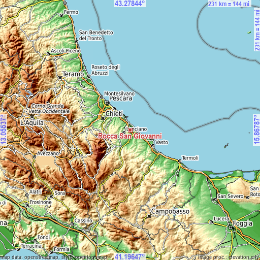
| \ | Map #1 | Topo.Map |
| Scale [m] | -2..273 m | × |
| Scale [ft] | -7..896 ft | × |
| Average | 137.5 m = 451 ft | × |
| Width | 7.23 km = 4.5 mi | 231.5 km = 143.8 mi |
| Height | 7.23 km = 4.5 mi | 231.5 km = 143.8 mi |
| ↑Max Latitude | 42.278563° | 43.27844° |
| Latitude at center | 42.24604° | 42.24604° |
| ↓Min Latitude | 42.2135° | 41.19647° |
| ← Min Longitude | 14.417675° | 13.05537° |
| Longitude center | 14.46162° | 14.46162° |
| →Max Longitude | 14.505565° | 15.86787° |
Nearby cities:
Cities around Rocca San Giovanni sort by population:
• Lanciano elevation 281 m
6.2 km,  250°
250°
• Fossacesia 150 m
1.8 km,  104°
104°
• Castel Frentano 365 m
10.1 km,  238°
238°
• Paglieta 229 m
10 km,  160°
160°
• San Vito Chietino 144 m
5.1 km,  342°
342°
• Frisa 233 m
7.4 km,  287°
287°
• Villa Caldari 185 m
9.9 km,  303°
303°
• Santa Maria Imbaro 221 m
3 km,  197°
197°
• Torino di Sangro 128 m
9.1 km,  132°
132°
• Marina di San Vito 27 m
6.7 km,  350°
350°
• Mozzagrogna 235 m
4 km, 202°
• Treglio 197 m
3.6 km, 299°
Multilingual:
 En español:
Rocca San Giovanni elevación 169 m.
 En France:
Rocca San Giovanni élévation 169 m.
 Auf Deutsch:
Rocca San Giovanni höhe über dem Meeresspiegel ist 169 m.
 На русском:
Rocca San Giovanni высота над уровнем моря 169 м
Sources and notes:
- [note 1] Map square and city borders are not equal. Map elevation data is calculated only from area inside that square.
- [src 1] Elevation data from geonames database provided with same terms of usage.
- [src 2] The elevation map of Rocca San Giovanni is generated using elevation data from NASA's 3 arcsec (90m) resolution SRTM data.
- [src 3] Base (background) map © OpenStreetMap contributors tiles are generated by Geofabrik and OpenTopoMap.
Copyright & License:
This Rocca San Giovanni Elevation Map is licensed under CC BY-SA. You may reuse any part from this page, if you give a proper credit by linking to this URL:
 More info on terms of use page.