Oyace elevation
Oyace (Aosta Valley, Valle d'Aosta), Italy elevation is 1369 meters and Oyace elevation in feet is 4491 ft above sea level [src 1]. Oyace is a seat of a third-order administrative division (feature code) with elevation that is 1047 meters (3435 ft) bigger than average city elevation in Italy.
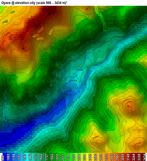
Below is the Elevation map of Oyace, which displays elevation range with different colors. Scale of the first map is from 968 to 3434 m (3176 to 11266 ft) with average elevation of 1989.1 meters (=6526 ft) [note 1]
These maps also provides idea of topography and contour of this city, they are displayed at different zoom levels. More info about maps, scale and edge coordinates you can find below images.
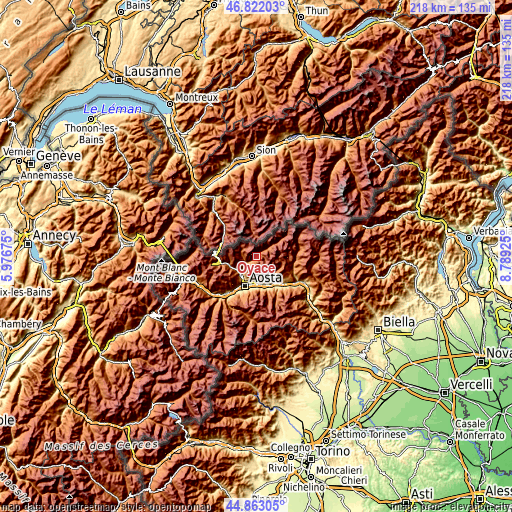
| \ | Map #1 | Topo.Map |
| Scale [m] | 968..3434 m | × |
| Scale [ft] | 3176..11266 ft | × |
| Average | 1989.1 m = 6526 ft | × |
| Width | 6.81 km = 4.2 mi | 217.8 km = 135.3 mi |
| Height | 6.81 km = 4.2 mi | 217.8 km = 135.3 mi |
| ↑Max Latitude | 45.881761° | 46.82203° |
| Latitude at center | 45.85116° | 45.85116° |
| ↓Min Latitude | 45.820543° | 44.86305° |
| ← Min Longitude | 7.339055° | 5.97675° |
| Longitude center | 7.383° | 7.383° |
| →Max Longitude | 7.426945° | 8.78925° |
Nearby cities:
Cities around Oyace sort by population:
• Quart elevation 541 m
12.5 km,  168°
168°
• Saint-Christophe 774 m
11.1 km,  194°
194°
• Chef-Lieu 692 m
11.4 km, 191°
• Villair-Amerique 618 m
11.5 km,  177°
177°
• La Cretaz-Roisan 873 m
9.2 km,  215°
215°
• Gignod 942 m
10.4 km, 220°
• Valpelline 949 m
5.3 km,  236°
236°
• Etroubles 1278 m
12.2 km,  253°
253°
• Doues 1184 m
6.9 km, 239°
• Allein 1215 m
9.8 km, 240°
• Ollomont 1375 m
5.6 km,  268°
268°
• Bionaz 1591 m
4 km,  51°
51°
Multilingual:
 En español:
Oyace elevación 1369 m.
 En France:
Oyace élévation 1369 m.


Sources and notes:
- [note 1] Map square and city borders are not equal. Map elevation data is calculated only from area inside that square.
- [src 1] Elevation data from geonames database provided with same terms of usage.
- [src 2] The elevation map of Oyace is generated using elevation data from NASA's 3 arcsec (90m) resolution SRTM data.
- [src 3] Base (background) map © OpenStreetMap contributors tiles are generated by Geofabrik and OpenTopoMap.
Copyright & License:
This Oyace Elevation Map is licensed under CC BY-SA. You may reuse any part from this page, if you give a proper credit by linking to this URL:
 More info on terms of use page.