Palanzano elevation
Palanzano (Emilia-Romagna, Provincia di Parma), Italy elevation is 659 meters and Palanzano elevation in feet is 2162 ft above sea level [src 1]. Palanzano is a seat of a third-order administrative division (feature code) with elevation that is 337 meters (1106 ft) bigger than average city elevation in Italy.
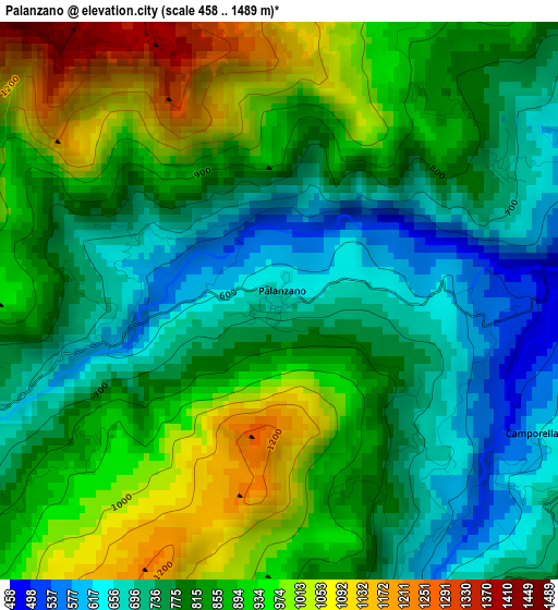
Below is the Elevation map of Palanzano, which displays elevation range with different colors. Scale of the first map is from 458 to 1489 m (1503 to 4885 ft) with average elevation of 837.6 meters (=2748 ft) [note 1]
These maps also provides idea of topography and contour of this city, they are displayed at different zoom levels. More info about maps, scale and edge coordinates you can find below images.
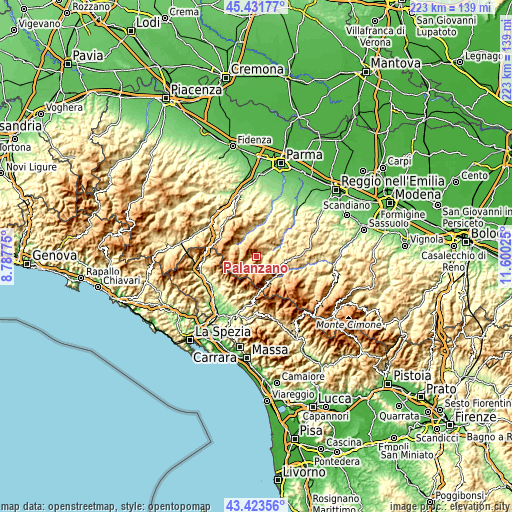
| \ | Map #1 | Topo.Map |
| Scale [m] | 458..1489 m | × |
| Scale [ft] | 1503..4885 ft | × |
| Average | 837.6 m = 2748 ft | × |
| Width | 6.98 km = 4.3 mi | 223.3 km = 138.8 mi |
| Height | 6.98 km = 4.3 mi | 223.3 km = 138.8 mi |
| ↑Max Latitude | 44.46766° | 45.43177° |
| Latitude at center | 44.43629° | 44.43629° |
| ↓Min Latitude | 44.404903° | 43.42356° |
| ← Min Longitude | 10.150055° | 8.78775° |
| Longitude center | 10.194° | 10.194° |
| →Max Longitude | 10.237945° | 11.60025° |
Nearby cities:
Cities around Palanzano sort by population:
• Castelnovo ne'Monti elevation 711 m
16.6 km,  90°
90°
• Berceto 809 m
18 km,  296°
296°
• Vetto 442 m
12.7 km,  65°
65°
• Collagna 838 m
11.8 km,  147°
147°
• Tizzano Val Parma 796 m
9.2 km,  2°
2°
• Ramiseto 782 m
7.1 km,  111°
111°
• Comano 535 m
16.7 km,  197°
197°
• Ligonchio 976 m
17.8 km,  138°
138°
• Busana 860 m
12.7 km,  126°
126°
• Monchio delle Corti 815 m
6.2 km,  243°
243°
• Corniglio 669 m
9.3 km, 297°
• Neviano degli Arduini 516 m
19 km,  30°
30°
Multilingual:
 En español:
Palanzano elevación 659 m.
 En France:
Palanzano élévation 659 m.
 Auf Deutsch:
Palanzano höhe über dem Meeresspiegel ist 659 m.

Sources and notes:
- [note 1] Map square and city borders are not equal. Map elevation data is calculated only from area inside that square.
- [src 1] Elevation data from geonames database provided with same terms of usage.
- [src 2] The elevation map of Palanzano is generated using elevation data from NASA's 3 arcsec (90m) resolution SRTM data.
- [src 3] Base (background) map © OpenStreetMap contributors tiles are generated by Geofabrik and OpenTopoMap.
Copyright & License:
This Palanzano Elevation Map is licensed under CC BY-SA. You may reuse any part from this page, if you give a proper credit by linking to this URL:
 More info on terms of use page.