Paularo elevation
Paularo (Friuli Venezia Giulia, Provincia di Udine), Italy elevation is 674 meters and Paularo elevation in feet is 2211 ft above sea level [src 1]. Paularo is a seat of a third-order administrative division (feature code) with elevation that is 352 meters (1155 ft) bigger than average city elevation in Italy.
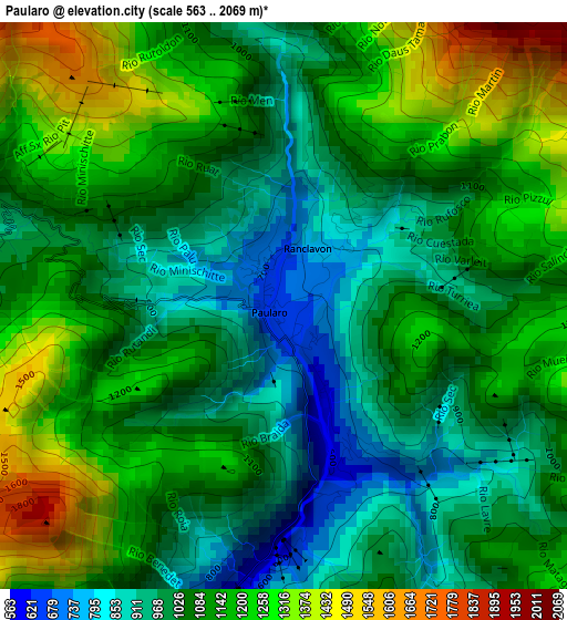
Below is the Elevation map of Paularo, which displays elevation range with different colors. Scale of the first map is from 563 to 2069 m (1847 to 6788 ft) with average elevation of 1090 meters (=3576 ft) [note 1]
These maps also provides idea of topography and contour of this city, they are displayed at different zoom levels. More info about maps, scale and edge coordinates you can find below images.
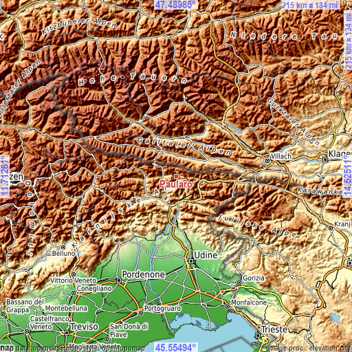
| \ | Map #1 | Topo.Map |
| Scale [m] | 563..2069 m | × |
| Scale [ft] | 1847..6788 ft | × |
| Average | 1090 m = 3576 ft | × |
| Width | 6.72 km = 4.2 mi | 215.1 km = 133.7 mi |
| Height | 6.72 km = 4.2 mi | 215.1 km = 133.7 mi |
| ↑Max Latitude | 46.561234° | 47.48985° |
| Latitude at center | 46.53101° | 46.53101° |
| ↓Min Latitude | 46.500769° | 45.55494° |
| ← Min Longitude | 13.074915° | 11.71261° |
| Longitude center | 13.11886° | 13.11886° |
| →Max Longitude | 13.162805° | 14.52511° |
Nearby cities:
Cities around Paularo sort by population:
• Tolmezzo elevation 312 m
16.4 km,  207°
207°
• Moggio Udinese 325 m
14.8 km,  154°
154°
• Arta Terme 487 m
9.4 km,  233°
233°
• Paluzza 593 m
7.9 km,  270°
270°
• Moggio di Sotto 320 m
15 km,  157°
157°
• Sutrio 527 m
9.8 km,  257°
257°
• Pontebba 562 m
14.6 km,  101°
101°
• Cercivento 597 m
9.7 km, 267°
• Treppo Carnico 672 m
5.8 km, 272°
• Zuglio 419 m
10.8 km,  221°
221°
• Ravascletto 944 m
15.1 km, 267°
• Ligosullo 959 m
3.5 km,  286°
286°
Multilingual:
 En español:
Paularo elevación 674 m.
 En France:
Paularo élévation 674 m.


Sources and notes:
- [note 1] Map square and city borders are not equal. Map elevation data is calculated only from area inside that square.
- [src 1] Elevation data from geonames database provided with same terms of usage.
- [src 2] The elevation map of Paularo is generated using elevation data from NASA's 3 arcsec (90m) resolution SRTM data.
- [src 3] Base (background) map © OpenStreetMap contributors tiles are generated by Geofabrik and OpenTopoMap.
Copyright & License:
This Paularo Elevation Map is licensed under CC BY-SA. You may reuse any part from this page, if you give a proper credit by linking to this URL:
 More info on terms of use page.