Moggio Udinese elevation
Moggio Udinese (Friuli Venezia Giulia, Provincia di Udine), Italy elevation is 325 meters and Moggio Udinese elevation in feet is 1066 ft above sea level [src 1]. Moggio Udinese is a seat of a third-order administrative division (feature code) with elevation that is 3 meters (10 ft) bigger than average city elevation in Italy.
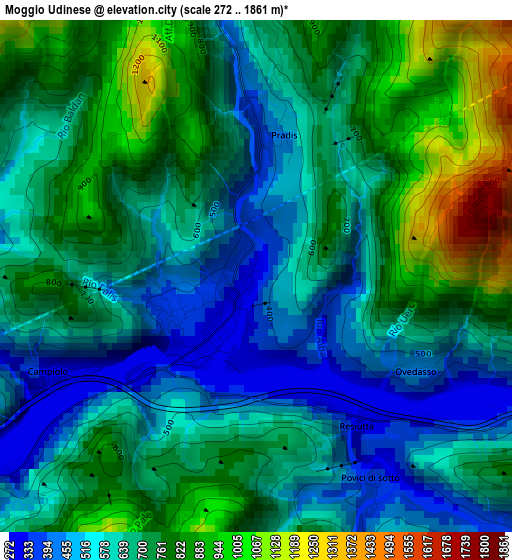
Below is the Elevation map of Moggio Udinese, which displays elevation range with different colors. Scale of the first map is from 272 to 1861 m (892 to 6106 ft) with average elevation of 674.9 meters (=2214 ft) [note 1]
These maps also provides idea of topography and contour of this city, they are displayed at different zoom levels. More info about maps, scale and edge coordinates you can find below images.
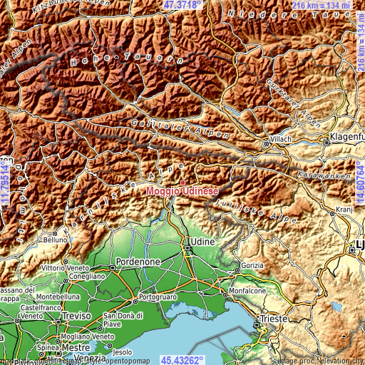
| \ | Map #1 | Topo.Map |
| Scale [m] | 272..1861 m | × |
| Scale [ft] | 892..6106 ft | × |
| Average | 674.9 m = 2214 ft | × |
| Width | 6.74 km = 4.2 mi | 215.6 km = 134 mi |
| Height | 6.74 km = 4.2 mi | 215.6 km = 134 mi |
| ↑Max Latitude | 46.441121° | 47.3718° |
| Latitude at center | 46.41083° | 46.41083° |
| ↓Min Latitude | 46.380522° | 45.43262° |
| ← Min Longitude | 13.157445° | 11.79514° |
| Longitude center | 13.20139° | 13.20139° |
| →Max Longitude | 13.245335° | 14.60764° |
Nearby cities:
Cities around Moggio Udinese sort by population:
• Tolmezzo elevation 312 m
13.9 km,  265°
265°
• Venzone 227 m
10.2 km,  208°
208°
• Moggio di Sotto 320 m
0.7 km,  225°
225°
• Pontebba 562 m
13.2 km,  37°
37°
• Amaro 298 m
9.2 km,  243°
243°
• Cavazzo Carnico 282 m
13.2 km,  248°
248°
• Bordano 221 m
12.9 km, 214°
• Zuglio 419 m
14.4 km,  291°
291°
• Prato 492 m
9.1 km,  117°
117°
• Chiusaforte 381 m
8 km,  93°
93°
• Resiutta 316 m
2.3 km,  146°
146°
• Dogna 440 m
9.6 km,  64°
64°
Multilingual:
 En español:
Moggio Udinese elevación 325 m.
 En France:
Moggio Udinese élévation 325 m.
 Auf Deutsch:
Moggio Udinese höhe über dem Meeresspiegel ist 325 m.

Sources and notes:
- [note 1] Map square and city borders are not equal. Map elevation data is calculated only from area inside that square.
- [src 1] Elevation data from geonames database provided with same terms of usage.
- [src 2] The elevation map of Moggio Udinese is generated using elevation data from NASA's 3 arcsec (90m) resolution SRTM data.
- [src 3] Base (background) map © OpenStreetMap contributors tiles are generated by Geofabrik and OpenTopoMap.
Copyright & License:
This Moggio Udinese Elevation Map is licensed under CC BY-SA. You may reuse any part from this page, if you give a proper credit by linking to this URL:
 More info on terms of use page.