Pennapiedimonte elevation
Pennapiedimonte (Abruzzo, Provincia di Chieti), Italy elevation is 670 meters and Pennapiedimonte elevation in feet is 2198 ft above sea level [src 1]. Pennapiedimonte is a seat of a third-order administrative division (feature code) with elevation that is 348 meters (1142 ft) bigger than average city elevation in Italy.
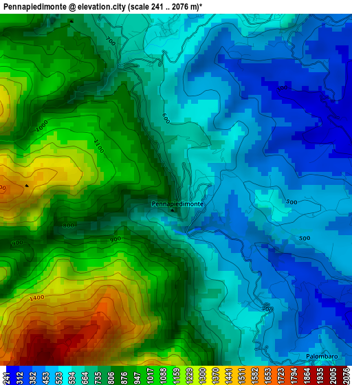
Below is the Elevation map of Pennapiedimonte, which displays elevation range with different colors. Scale of the first map is from 241 to 2076 m (791 to 6811 ft) with average elevation of 776.1 meters (=2546 ft) [note 1]
These maps also provides idea of topography and contour of this city, they are displayed at different zoom levels. More info about maps, scale and edge coordinates you can find below images.
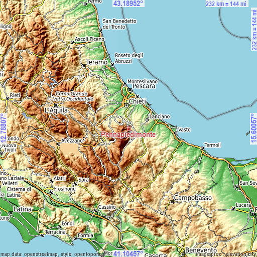
| \ | Map #1 | Topo.Map |
| Scale [m] | 241..2076 m | × |
| Scale [ft] | 791..6811 ft | × |
| Average | 776.1 m = 2546 ft | × |
| Width | 7.24 km = 4.5 mi | 231.8 km = 144 mi |
| Height | 7.24 km = 4.5 mi | 231.8 km = 144 mi |
| ↑Max Latitude | 42.188199° | 43.18952° |
| Latitude at center | 42.15563° | 42.15563° |
| ↓Min Latitude | 42.123044° | 41.10457° |
| ← Min Longitude | 14.150375° | 12.78807° |
| Longitude center | 14.19432° | 14.19432° |
| →Max Longitude | 14.238265° | 15.60057° |
Nearby cities:
Cities around Pennapiedimonte sort by population:
• Guardiagrele elevation 532 m
4.7 km,  25°
25°
• Orsogna 411 m
10.4 km,  43°
43°
• Casoli 348 m
9.2 km,  120°
120°
• Fara San Martino 422 m
7.1 km,  170°
170°
• Fara Filiorum Petri 257 m
9.6 km,  353°
353°
• Rapino 401 m
6 km, 352°
• Casacanditella 421 m
10.1 km,  2°
2°
• Palombaro 521 m
4.6 km,  140°
140°
• Pretoro 502 m
8.3 km,  328°
328°
• Filetto 427 m
9.2 km, 27°
• San Martino sulla Marrucina 398 m
7.8 km,  13°
13°
• Civitella Messer Raimondo 597 m
7.6 km, 165°
Multilingual:
 En español:
Pennapiedimonte elevación 670 m.
 En France:
Pennapiedimonte élévation 670 m.
 Auf Deutsch:
Pennapiedimonte höhe über dem Meeresspiegel ist 670 m.

Sources and notes:
- [note 1] Map square and city borders are not equal. Map elevation data is calculated only from area inside that square.
- [src 1] Elevation data from geonames database provided with same terms of usage.
- [src 2] The elevation map of Pennapiedimonte is generated using elevation data from NASA's 3 arcsec (90m) resolution SRTM data.
- [src 3] Base (background) map © OpenStreetMap contributors tiles are generated by Geofabrik and OpenTopoMap.
Copyright & License:
This Pennapiedimonte Elevation Map is licensed under CC BY-SA. You may reuse any part from this page, if you give a proper credit by linking to this URL:
 More info on terms of use page.