Orsogna elevation
Orsogna (Abruzzo, Provincia di Chieti), Italy elevation is 411 meters and Orsogna elevation in feet is 1348 ft above sea level [src 1]. Orsogna is a seat of a third-order administrative division (feature code) with elevation that is 89 meters (292 ft) bigger than average city elevation in Italy.
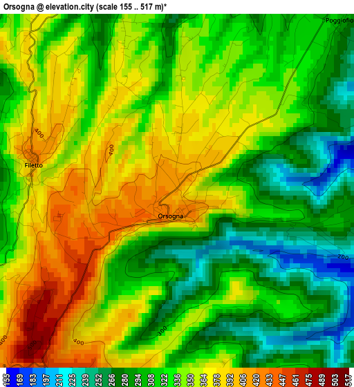
Below is the Elevation map of Orsogna, which displays elevation range with different colors. Scale of the first map is from 155 to 517 m (509 to 1696 ft) with average elevation of 333.5 meters (=1094 ft) [note 1]
These maps also provides idea of topography and contour of this city, they are displayed at different zoom levels. More info about maps, scale and edge coordinates you can find below images.
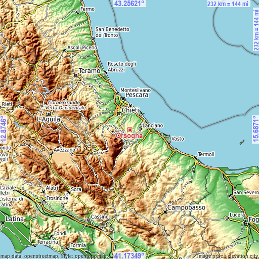
| \ | Map #1 | Topo.Map |
| Scale [m] | 155..517 m | × |
| Scale [ft] | 509..1696 ft | × |
| Average | 333.5 m = 1094 ft | × |
| Width | 7.24 km = 4.5 mi | 231.6 km = 143.9 mi |
| Height | 7.24 km = 4.5 mi | 231.6 km = 143.9 mi |
| ↑Max Latitude | 42.255974° | 43.25621° |
| Latitude at center | 42.22344° | 42.22344° |
| ↓Min Latitude | 42.190889° | 41.17349° |
| ← Min Longitude | 14.236905° | 12.8746° |
| Longitude center | 14.28085° | 14.28085° |
| →Max Longitude | 14.324795° | 15.6871° |
Nearby cities:
Cities around Orsogna sort by population:
• Guardiagrele elevation 532 m
6 km,  237°
237°
• Castel Frentano 365 m
6.8 km,  113°
113°
• Fara Filiorum Petri 257 m
8.5 km,  283°
283°
• Rapino 401 m
8.1 km,  258°
258°
• Canosa Sannita 239 m
8.3 km,  13°
13°
• Casacanditella 421 m
7.1 km,  291°
291°
• Sant'Eusanio del Sangro 214 m
7.2 km,  147°
147°
• Poggiofiorito 298 m
4.7 km,  43°
43°
• Arielli 304 m
4.7 km,  30°
30°
• Filetto 427 m
3 km, 282°
• San Martino sulla Marrucina 398 m
5.4 km,  270°
270°
• Ari 290 m
7.6 km,  346°
346°
Multilingual:
 En español:
Orsogna elevación 411 m.
 En France:
Orsogna élévation 411 m.


Sources and notes:
- [note 1] Map square and city borders are not equal. Map elevation data is calculated only from area inside that square.
- [src 1] Elevation data from geonames database provided with same terms of usage.
- [src 2] The elevation map of Orsogna is generated using elevation data from NASA's 3 arcsec (90m) resolution SRTM data.
- [src 3] Base (background) map © OpenStreetMap contributors tiles are generated by Geofabrik and OpenTopoMap.
Copyright & License:
This Orsogna Elevation Map is licensed under CC BY-SA. You may reuse any part from this page, if you give a proper credit by linking to this URL:
 More info on terms of use page.