Pereto elevation
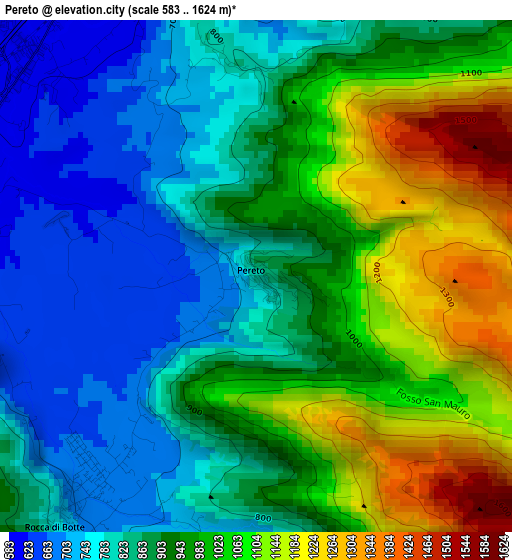
Pereto (Abruzzo, Provincia dell' Aquila), Italy elevation is 817 meters and Pereto elevation in feet is 2680 ft above sea level [src 1]. Pereto is a seat of a third-order administrative division (feature code) with elevation that is 495 meters (1624 ft) bigger than average city elevation in Italy.
Below is the Elevation map of Pereto, which displays elevation range with different colors. Scale of the first map is from 583 to 1624 m (1913 to 5328 ft) with average elevation of 923.7 meters (=3031 ft) [note 1]
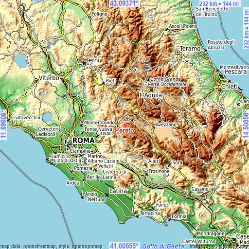
These maps also provides idea of topography and contour of this city, they are displayed at different zoom levels. More info about maps, scale and edge coordinates you can find below images.
| \ | Map #1 | Topo.Map |
| Scale [m] | 583..1624 m | × |
| Scale [ft] | 1913..5328 ft | × |
| Average | 923.7 m = 3031 ft | × |
| Width | 7.26 km = 4.5 mi | 232.2 km = 144.3 mi |
| Height | 7.26 km = 4.5 mi | 232.2 km = 144.3 mi |
| ↑Max Latitude | 42.090829° | 43.09371° |
| Latitude at center | 42.05821° | 42.05821° |
| ↓Min Latitude | 42.025574° | 41.00555° |
| ← Min Longitude | 13.058365° | 11.69606° |
| Longitude center | 13.10231° | 13.10231° |
| →Max Longitude | 13.146255° | 14.50856° |
Nearby cities:
Cities around Pereto sort by population:
• Carsoli elevation 612 m
4.7 km,  345°
345°
• Arsoli 481 m
7.4 km,  255°
255°
• Roviano 494 m
9.6 km,  248°
248°
• Riofreddo 670 m
8.7 km,  270°
270°
• Rocca di Botte 676 m
3.9 km,  219°
219°
• Sante Marie 863 m
9.6 km,  58°
58°
• Oricola 801 m
5.3 km, 259°
• Camerata Nuova 800 m
4.5 km,  172°
172°
• Collalto Sabino 916 m
9.6 km,  332°
332°
• Vallinfreda 832 m
9.3 km,  288°
288°
• Vivaro Romano 765 m
9.3 km,  300°
300°
• Cervara di Roma 1038 m
8.3 km,  200°
200°
Multilingual:
 En español:
Pereto elevación 817 m.
 En France:
Pereto élévation 817 m.


Sources and notes:
- [note 1] Map square and city borders are not equal. Map elevation data is calculated only from area inside that square.
- [src 1] Elevation data from geonames database provided with same terms of usage.
- [src 2] The elevation map of Pereto is generated using elevation data from NASA's 3 arcsec (90m) resolution SRTM data.
- [src 3] Base (background) map © OpenStreetMap contributors tiles are generated by Geofabrik and OpenTopoMap.
Copyright & License:
This Pereto Elevation Map is licensed under CC BY-SA. You may reuse any part from this page, if you give a proper credit by linking to this URL:
 More info on terms of use page.