Riofreddo elevation
Riofreddo (Latium, Città metropolitana di Roma Capitale), Italy elevation is 670 meters and Riofreddo elevation in feet is 2198 ft above sea level [src 1]. Riofreddo is a seat of a third-order administrative division (feature code) with elevation that is 348 meters (1142 ft) bigger than average city elevation in Italy.
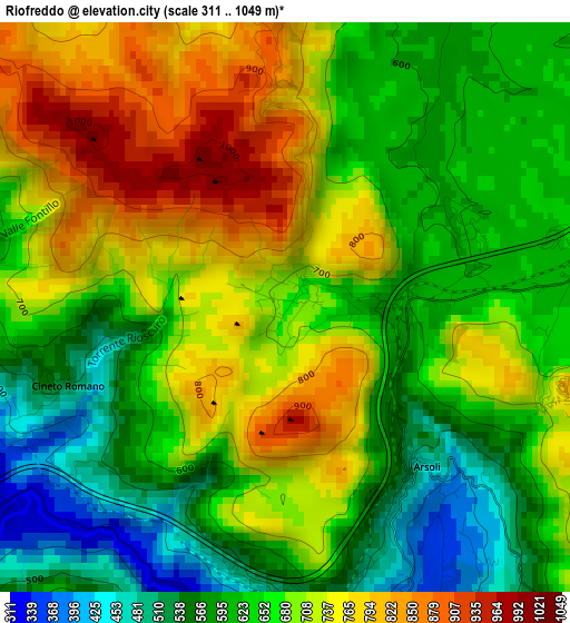
Below is the Elevation map of Riofreddo, which displays elevation range with different colors. Scale of the first map is from 311 to 1049 m (1020 to 3442 ft) with average elevation of 668.9 meters (=2195 ft) [note 1]
These maps also provides idea of topography and contour of this city, they are displayed at different zoom levels. More info about maps, scale and edge coordinates you can find below images.
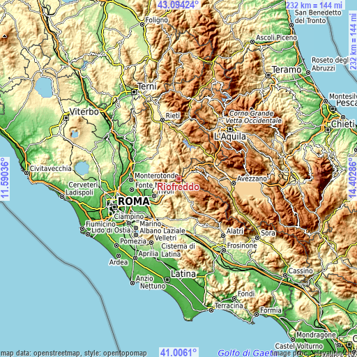
| \ | Map #1 | Topo.Map |
| Scale [m] | 311..1049 m | × |
| Scale [ft] | 1020..3442 ft | × |
| Average | 668.9 m = 2195 ft | × |
| Width | 7.26 km = 4.5 mi | 232.2 km = 144.3 mi |
| Height | 7.26 km = 4.5 mi | 232.2 km = 144.3 mi |
| ↑Max Latitude | 42.091369° | 43.09424° |
| Latitude at center | 42.05875° | 42.05875° |
| ↓Min Latitude | 42.026114° | 41.0061° |
| ← Min Longitude | 12.952665° | 11.59036° |
| Longitude center | 12.99661° | 12.99661° |
| →Max Longitude | 13.040555° | 14.40286° |
Nearby cities:
Cities around Riofreddo sort by population:
• Arsoli elevation 481 m
2.5 km,  139°
139°
• Roviano 494 m
3.6 km,  183°
183°
• Anticoli Corrado 551 m
5.7 km,  185°
185°
• Marano Equo 451 m
7.2 km,  167°
167°
• Rocca di Botte 676 m
6.9 km,  116°
116°
• Cineto Romano 526 m
3.1 km,  252°
252°
• Mandela 418 m
7.1 km,  241°
241°
• Oricola 801 m
3.7 km,  106°
106°
• Roccagiovine 530 m
8.1 km,  263°
263°
• Vallinfreda 832 m
2.9 km,  358°
358°
• Vivaro Romano 765 m
4.8 km,  9°
9°
• Saracinesco 883 m
7.1 km,  210°
210°
Multilingual:
 En español:
Riofreddo elevación 670 m.
 En France:
Riofreddo élévation 670 m.
 Auf Deutsch:
Riofreddo höhe über dem Meeresspiegel ist 670 m.

Sources and notes:
- [note 1] Map square and city borders are not equal. Map elevation data is calculated only from area inside that square.
- [src 1] Elevation data from geonames database provided with same terms of usage.
- [src 2] The elevation map of Riofreddo is generated using elevation data from NASA's 3 arcsec (90m) resolution SRTM data.
- [src 3] Base (background) map © OpenStreetMap contributors tiles are generated by Geofabrik and OpenTopoMap.
Copyright & License:
This Riofreddo Elevation Map is licensed under CC BY-SA. You may reuse any part from this page, if you give a proper credit by linking to this URL:
 More info on terms of use page.