Piedimonte elevation
Piedimonte (Campania, Provincia di Caserta), Italy elevation is 40 meters and Piedimonte elevation in feet is 131 ft above sea level [src 1]. Piedimonte is a populated place (feature code) with elevation that is 282 meters (925 ft) smaller than average city elevation in Italy.
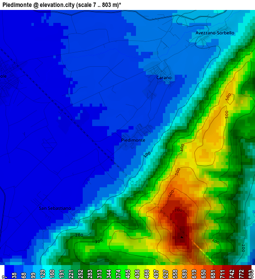
Below is the Elevation map of Piedimonte, which displays elevation range with different colors. Scale of the first map is from 7 to 803 m (23 to 2635 ft) with average elevation of 176.4 meters (=579 ft) [note 1]
These maps also provides idea of topography and contour of this city, they are displayed at different zoom levels. More info about maps, scale and edge coordinates you can find below images.
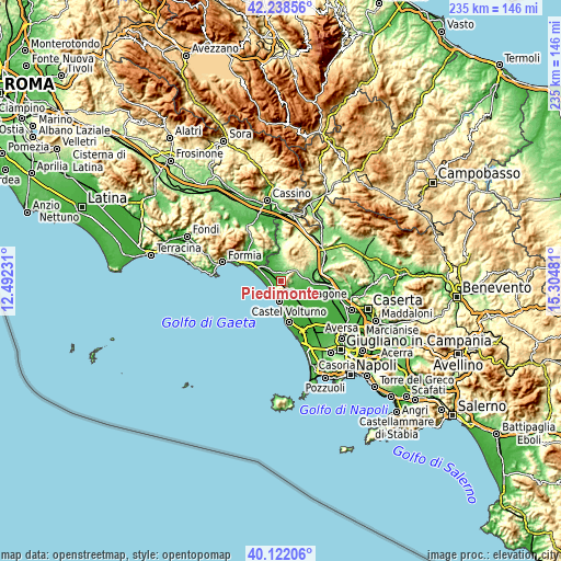
| \ | Map #1 | Topo.Map |
| Scale [m] | 7..803 m | × |
| Scale [ft] | 23..2635 ft | × |
| Average | 176.4 m = 579 ft | × |
| Width | 7.35 km = 4.6 mi | 235.3 km = 146.2 mi |
| Height | 7.35 km = 4.6 mi | 235.3 km = 146.2 mi |
| ↑Max Latitude | 41.221922° | 42.23856° |
| Latitude at center | 41.18886° | 41.18886° |
| ↓Min Latitude | 41.155781° | 40.12206° |
| ← Min Longitude | 13.854615° | 12.49231° |
| Longitude center | 13.89856° | 13.89856° |
| →Max Longitude | 13.942505° | 15.30481° |
Nearby cities:
Cities around Piedimonte sort by population:
• Mondragone elevation 8 m
8.3 km,  184°
184°
• Cellole 21 m
4.1 km,  293°
293°
• Sessa Aurunca 201 m
6.2 km,  24°
24°
• Falciano del Massico 65 m
5.1 km,  125°
125°
• Nocelleto 45 m
10 km,  101°
101°
• Carano 72 m
2 km,  27°
27°
• Casanova 102 m
5.4 km,  85°
85°
• Lauro 100 m
8.3 km,  355°
355°
• Casale 178 m
9.3 km,  68°
68°
• Carinola 72 m
7 km, 91°
• Cascano 217 m
7.6 km,  50°
50°
• San Castrese 42 m
8.2 km,  340°
340°
Multilingual:
 En español:
Piedimonte elevación 40 m.
 En France:
Piedimonte élévation 40 m.
 Auf Deutsch:
Piedimonte höhe über dem Meeresspiegel ist 40 m.

Sources and notes:
- [note 1] Map square and city borders are not equal. Map elevation data is calculated only from area inside that square.
- [src 1] Elevation data from geonames database provided with same terms of usage.
- [src 2] The elevation map of Piedimonte is generated using elevation data from NASA's 3 arcsec (90m) resolution SRTM data.
- [src 3] Base (background) map © OpenStreetMap contributors tiles are generated by Geofabrik and OpenTopoMap.
Copyright & License:
This Piedimonte Elevation Map is licensed under CC BY-SA. You may reuse any part from this page, if you give a proper credit by linking to this URL:
 More info on terms of use page.