Pistoia elevation
Pistoia (Tuscany, Provincia di Pistoia), Italy elevation is 63 meters and Pistoia elevation in feet is 207 ft above sea level [src 1]. Pistoia is a seat of a second-order administrative division (feature code) with elevation that is 259 meters (850 ft) smaller than average city elevation in Italy.
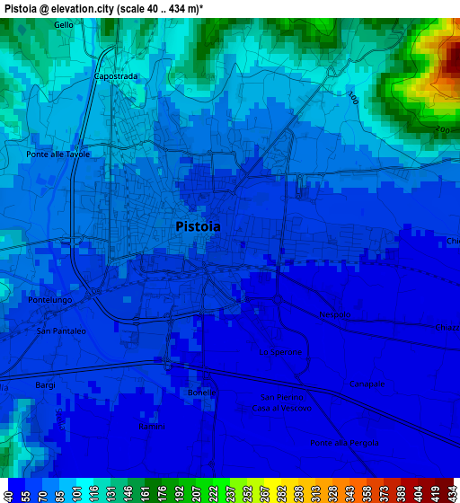
Below is the Elevation map of Pistoia, which displays elevation range with different colors. Scale of the first map is from 40 to 434 m (131 to 1424 ft) with average elevation of 79.8 meters (=262 ft) [note 1]
These maps also provides idea of topography and contour of this city, they are displayed at different zoom levels. More info about maps, scale and edge coordinates you can find below images.
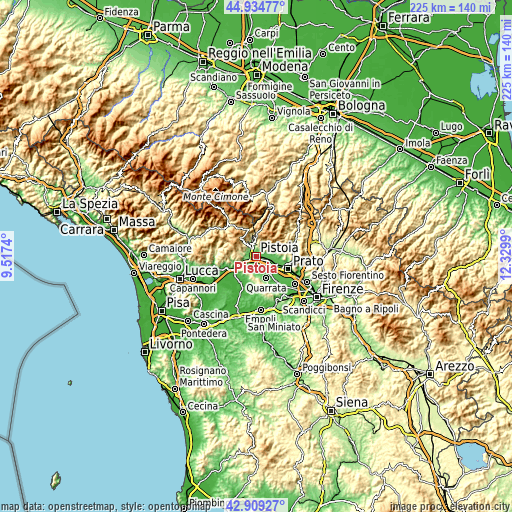
| \ | Map #1 | Map #2 | Topo.Map |
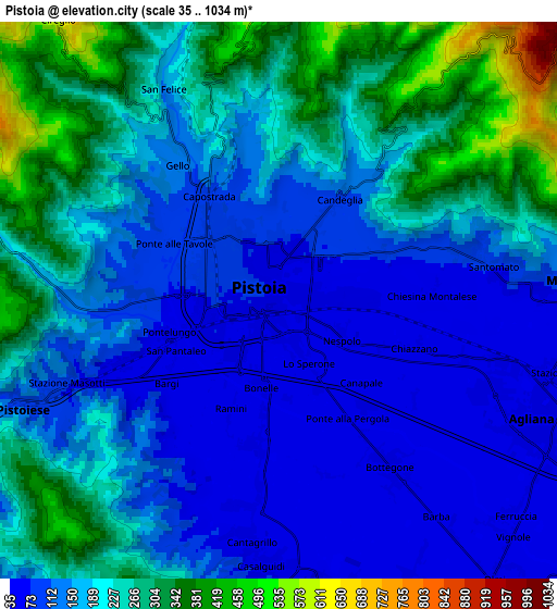
| Scale [m] | 40..434 m | 35..1034 m | × |
| Scale [ft] | 131..1424 ft | 115..3392 ft | × |
| Average | 79.8 m = 262 ft | 187.2 m = 614 ft | × |
| Width | 7.04 km = 4.4 mi | 14.08 km = 8.7 mi | 225.2 km = 139.9 mi |
| Height | 7.04 km = 4.4 mi | 14.08 km = 8.7 mi | 225.2 km = 139.9 mi |
| ↑Max Latitude | 43.96228° | 43.993903° | 44.93477° |
| Latitude at center | 43.93064° | 43.93064° | 43.93064° |
| ↓Min Latitude | 43.898983° | 43.867309° | 42.90927° |
| ← Min Longitude | 10.879705° | 10.835759° | 9.5174° |
| Longitude center | 10.92365° | 10.92365° | 10.92365° |
| →Max Longitude | 10.967595° | 11.011541° | 12.3299° |
Nearby cities:
Cities around Pistoia sort by population:
• Montemurlo elevation 78 m
9.1 km,  92°
92°
• Fornacelle 68 m
9 km, 94°
• Agliana 45 m
7.3 km,  115°
115°
• Quarrata 48 m
10.2 km,  154°
154°
• Cantagrillo-Casalguidi 76 m
6.9 km,  186°
186°
• Montale 86 m
7.5 km, 86°
• Stazione 57 m
7.5 km,  103°
103°
• Valenzatico 41 m
7.8 km, 154°
• Vignole-Olmi 39 m
8.9 km,  142°
142°
• Barba 40 m
6.8 km, 141°
• Stazione Masotti 74 m
6 km,  247°
247°
• Serravalle Pistoiese 176 m
7.8 km, 249°
Multilingual:
 En español:
Pistoia elevación 63 m.
 En France:
Pistoia élévation 63 m.


Sources and notes:
- [note 1] Map square and city borders are not equal. Map elevation data is calculated only from area inside that square.
- [src 1] Elevation data from geonames database provided with same terms of usage.
- [src 2] The elevation map of Pistoia is generated using elevation data from NASA's 3 arcsec (90m) resolution SRTM data.
- [src 3] Base (background) map © OpenStreetMap contributors tiles are generated by Geofabrik and OpenTopoMap.
Copyright & License:
This Pistoia Elevation Map is licensed under CC BY-SA. You may reuse any part from this page, if you give a proper credit by linking to this URL:
 More info on terms of use page.