Poiano elevation
Poiano (Veneto, Provincia di Verona), Italy elevation is 72 meters and Poiano elevation in feet is 236 ft above sea level [src 1]. Poiano is a populated place (feature code) with elevation that is 250 meters (820 ft) smaller than average city elevation in Italy.
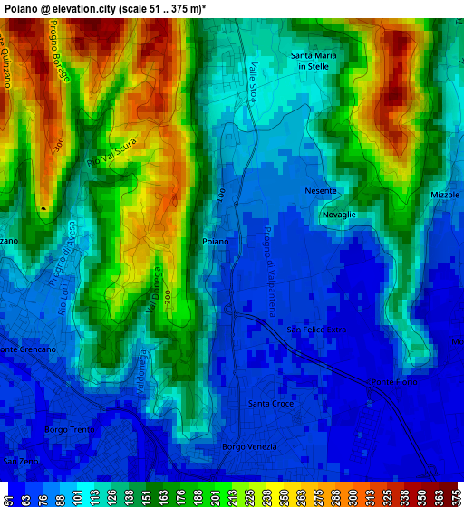
Below is the Elevation map of Poiano, which displays elevation range with different colors. Scale of the first map is from 51 to 375 m (167 to 1230 ft) with average elevation of 135.7 meters (=445 ft) [note 1]
These maps also provides idea of topography and contour of this city, they are displayed at different zoom levels. More info about maps, scale and edge coordinates you can find below images.
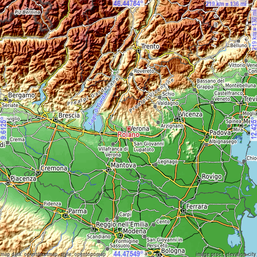
| \ | Map #1 | Topo.Map |
| Scale [m] | 51..375 m | × |
| Scale [ft] | 167..1230 ft | × |
| Average | 135.7 m = 445 ft | × |
| Width | 6.85 km = 4.3 mi | 219.3 km = 136.3 mi |
| Height | 6.85 km = 4.3 mi | 219.3 km = 136.3 mi |
| ↑Max Latitude | 45.5011° | 46.44784° |
| Latitude at center | 45.47029° | 45.47029° |
| ↓Min Latitude | 45.439464° | 44.47549° |
| ← Min Longitude | 10.974805° | 9.6125° |
| Longitude center | 11.01875° | 11.01875° |
| →Max Longitude | 11.062695° | 12.425° |
Nearby cities:
Cities around Poiano sort by population:
• Verona elevation 62 m
5.2 km,  210°
210°
• San Martino Buon Albergo 46 m
8.1 km,  132°
132°
• Negrar 184 m
9 km,  316°
316°
• Montorio 55 m
3.9 km,  109°
109°
• Arbizzano-Santa Maria 90 m
6.8 km,  293°
293°
• Grezzana 176 m
5.8 km,  358°
358°
• Pedemonte 112 m
8.6 km,  295°
295°
• Parona 71 m
5.9 km,  279°
279°
• San Pietro 70 m
9.2 km, 109°
• Corrubbio 109 m
9.2 km, 281°
• Settimo 83 m
8.6 km, 276°
• Mezzane di Sotto 121 m
8.6 km,  81°
81°
Multilingual:
 En español:
Poiano elevación 72 m.
 En France:
Poiano élévation 72 m.


Sources and notes:
- [note 1] Map square and city borders are not equal. Map elevation data is calculated only from area inside that square.
- [src 1] Elevation data from geonames database provided with same terms of usage.
- [src 2] The elevation map of Poiano is generated using elevation data from NASA's 3 arcsec (90m) resolution SRTM data.
- [src 3] Base (background) map © OpenStreetMap contributors tiles are generated by Geofabrik and OpenTopoMap.
Copyright & License:
This Poiano Elevation Map is licensed under CC BY-SA. You may reuse any part from this page, if you give a proper credit by linking to this URL:
 More info on terms of use page.