Pometo elevation
Pometo (Lombardy, Provincia di Pavia), Italy elevation is 522 meters and Pometo elevation in feet is 1713 ft above sea level [src 1]. Pometo is a seat of a third-order administrative division (feature code) with elevation that is 200 meters (656 ft) bigger than average city elevation in Italy.
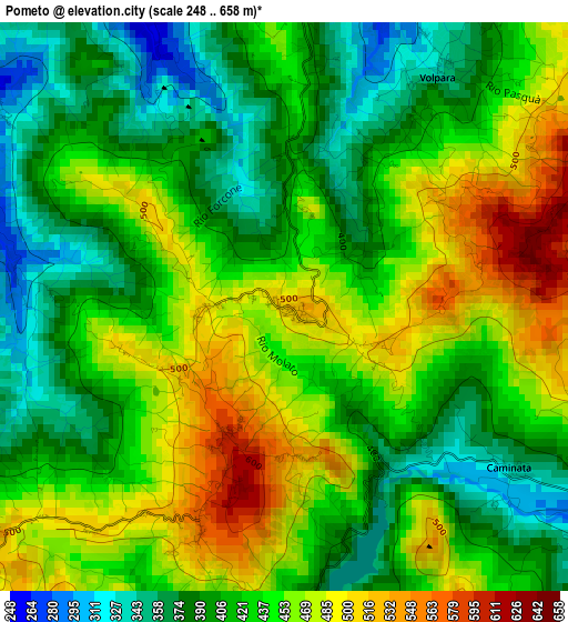
Below is the Elevation map of Pometo, which displays elevation range with different colors. Scale of the first map is from 248 to 658 m (814 to 2159 ft) with average elevation of 431.6 meters (=1416 ft) [note 1]
These maps also provides idea of topography and contour of this city, they are displayed at different zoom levels. More info about maps, scale and edge coordinates you can find below images.
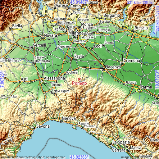
| \ | Map #1 | Topo.Map |
| Scale [m] | 248..658 m | × |
| Scale [ft] | 814..2159 ft | × |
| Average | 431.6 m = 1416 ft | × |
| Width | 6.92 km = 4.3 mi | 221.4 km = 137.6 mi |
| Height | 6.92 km = 4.3 mi | 221.4 km = 137.6 mi |
| ↑Max Latitude | 44.958985° | 45.91487° |
| Latitude at center | 44.92788° | 44.92788° |
| ↓Min Latitude | 44.896758° | 43.92363° |
| ← Min Longitude | 9.229535° | 7.86723° |
| Longitude center | 9.27348° | 9.27348° |
| →Max Longitude | 9.317425° | 10.67973° |
Nearby cities:
Cities around Pometo sort by population:
• Santa Maria della Versa elevation 198 m
7 km,  17°
17°
• Montecalvo Versiggia 357 m
5 km,  10°
10°
• Zavattarello 544 m
6.7 km,  184°
184°
• Nibbiano 290 m
5 km,  120°
120°
• Caminata 351 m
3.4 km,  125°
125°
• Borgoratto Mormorolo 346 m
6.3 km,  271°
271°
• Volpara 343 m
3.4 km,  33°
33°
• Golferenzo 432 m
4.5 km, 34°
• Fortunago 459 m
7 km,  264°
264°
• Caseo 408 m
1.8 km,  3°
3°
• Ruino 539 m
1.8 km,  174°
174°
• Villa Fornace 219 m
5.2 km,  341°
341°
Multilingual:
 En español:
Pometo elevación 522 m.
 En France:
Pometo élévation 522 m.


Sources and notes:
- [note 1] Map square and city borders are not equal. Map elevation data is calculated only from area inside that square.
- [src 1] Elevation data from geonames database provided with same terms of usage.
- [src 2] The elevation map of Pometo is generated using elevation data from NASA's 3 arcsec (90m) resolution SRTM data.
- [src 3] Base (background) map © OpenStreetMap contributors tiles are generated by Geofabrik and OpenTopoMap.
Copyright & License:
This Pometo Elevation Map is licensed under CC BY-SA. You may reuse any part from this page, if you give a proper credit by linking to this URL:
 More info on terms of use page.