Pontestura elevation
Pontestura (Piedmont, Provincia di Alessandria), Italy elevation is 142 meters and Pontestura elevation in feet is 466 ft above sea level [src 1]. Pontestura is a seat of a third-order administrative division (feature code) with elevation that is 180 meters (591 ft) smaller than average city elevation in Italy.
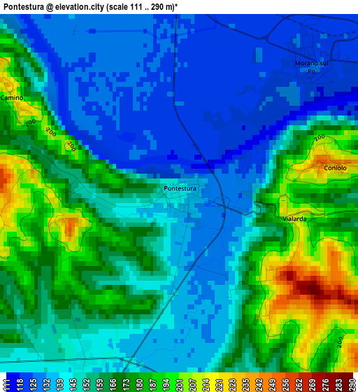
Below is the Elevation map of Pontestura, which displays elevation range with different colors. Scale of the first map is from 111 to 290 m (364 to 951 ft) with average elevation of 156.1 meters (=512 ft) [note 1]
These maps also provides idea of topography and contour of this city, they are displayed at different zoom levels. More info about maps, scale and edge coordinates you can find below images.
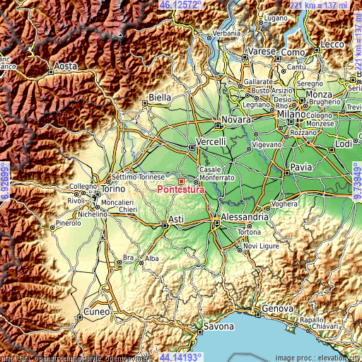
| \ | Map #1 | Topo.Map |
| Scale [m] | 111..290 m | × |
| Scale [ft] | 364..951 ft | × |
| Average | 156.1 m = 512 ft | × |
| Width | 6.89 km = 4.3 mi | 220.6 km = 137.1 mi |
| Height | 6.89 km = 4.3 mi | 220.6 km = 137.1 mi |
| ↑Max Latitude | 45.173438° | 46.12572° |
| Latitude at center | 45.14245° | 45.14245° |
| ↓Min Latitude | 45.111445° | 44.14193° |
| ← Min Longitude | 8.289295° | 6.92699° |
| Longitude center | 8.33324° | 8.33324° |
| →Max Longitude | 8.377185° | 9.73949° |
Nearby cities:
Cities around Pontestura sort by population:
• Trino elevation 136 m
6.6 km,  333°
333°
• Balzola 121 m
7.1 km,  50°
50°
• Morano sul Po 121 m
3.7 km,  44°
44°
• Ozzano Monferrato 198 m
5.1 km,  142°
142°
• San Giorgio 230 m
7.4 km,  121°
121°
• Camino 221 m
3.5 km,  297°
297°
• Coniolo Bricco 226 m
3 km,  77°
77°
• Cereseto 230 m
6.3 km,  190°
190°
• Mombello Monferrato 262 m
6.6 km,  260°
260°
• Treville 268 m
5.5 km,  157°
157°
• Serralunga di Crea 242 m
6.2 km,  221°
221°
• Solonghello 182 m
4.2 km,  249°
249°
Multilingual:
 En español:
Pontestura elevación 142 m.
 En France:
Pontestura élévation 142 m.
 Auf Deutsch:
Pontestura höhe über dem Meeresspiegel ist 142 m.

Sources and notes:
- [note 1] Map square and city borders are not equal. Map elevation data is calculated only from area inside that square.
- [src 1] Elevation data from geonames database provided with same terms of usage.
- [src 2] The elevation map of Pontestura is generated using elevation data from NASA's 3 arcsec (90m) resolution SRTM data.
- [src 3] Base (background) map © OpenStreetMap contributors tiles are generated by Geofabrik and OpenTopoMap.
Copyright & License:
This Pontestura Elevation Map is licensed under CC BY-SA. You may reuse any part from this page, if you give a proper credit by linking to this URL:
 More info on terms of use page.