Porcari elevation
Porcari (Tuscany, Provincia di Lucca), Italy elevation is 17 meters and Porcari elevation in feet is 56 ft above sea level [src 1]. Porcari is a seat of a third-order administrative division (feature code) with elevation that is 305 meters (1001 ft) smaller than average city elevation in Italy.
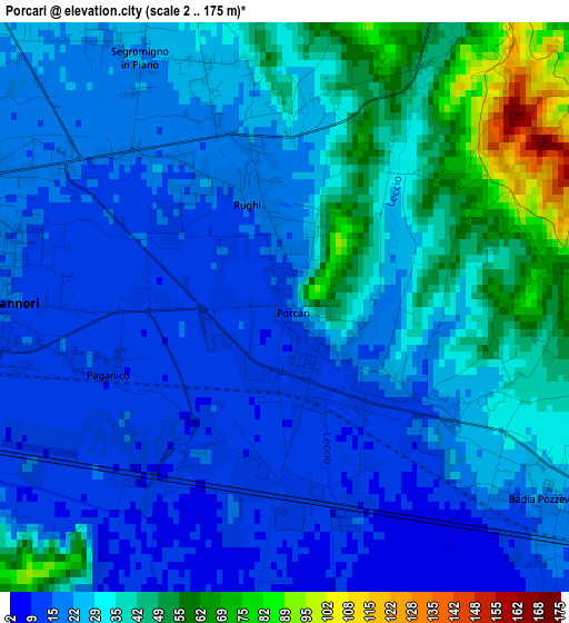
Below is the Elevation map of Porcari, which displays elevation range with different colors. Scale of the first map is from 2 to 175 m (7 to 574 ft) with average elevation of 28.4 meters (=93 ft) [note 1]
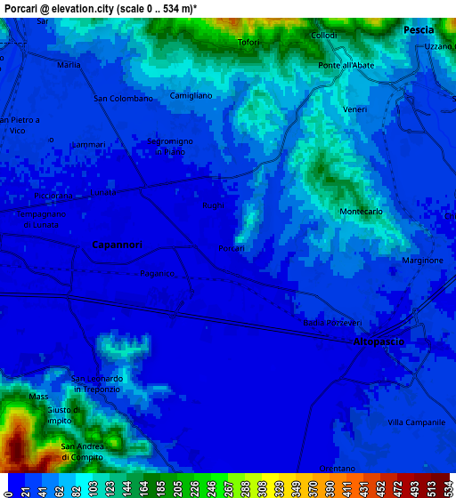
These maps also provides idea of topography and contour of this city, they are displayed at different zoom levels. More info about maps, scale and edge coordinates you can find below images.
| \ | Map #1 | Map #2 | Topo.Map |
| Scale [m] | 2..175 m | 0..534 m | × |
| Scale [ft] | 7..574 ft | 0..1752 ft | × |
| Average | 28.4 m = 93 ft | 50.6 m = 166 ft | × |
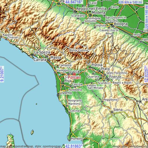
| Width | 7.05 km = 4.4 mi | 14.1 km = 8.8 mi | 225.6 km = 140.2 mi |
| Height | 7.05 km = 4.4 mi | 14.1 km = 8.8 mi | 225.5 km = 140.1 mi |
| ↑Max Latitude | 43.873208° | 43.904878° | 44.84716° |
| Latitude at center | 43.84152° | 43.84152° | 43.84152° |
| ↓Min Latitude | 43.809816° | 43.778094° | 42.81863° |
| ← Min Longitude | 10.572375° | 10.528429° | 9.21007° |
| Longitude center | 10.61632° | 10.61632° | 10.61632° |
| →Max Longitude | 10.660265° | 10.704211° | 12.02257° |
Nearby cities:
Cities around Porcari sort by population:
• Lucca elevation 29 m
9 km,  271°
271°
• Capannori 15 m
3.5 km, 270°
• Pescia 42 m
7.7 km,  48°
48°
• Altopascio 15 m
5.6 km,  120°
120°
• Borgo a Buggiano 32 m
10.2 km,  68°
68°
• Santa Lucia 46 m
8.3 km,  56°
56°
• Chiesina Uzzanese 22 m
8.4 km,  91°
91°
• Orentano 29 m
7.8 km,  153°
153°
• Spianate 27 m
8.6 km,  113°
113°
• Villa Basilica 335 m
9.6 km,  13°
13°
• Montecarlo 152 m
4.3 km, 73°
• Uzzano 254 m
9.4 km, 48°
Multilingual:
 En español:
Porcari elevación 17 m.
 En France:
Porcari élévation 17 m.


Sources and notes:
- [note 1] Map square and city borders are not equal. Map elevation data is calculated only from area inside that square.
- [src 1] Elevation data from geonames database provided with same terms of usage.
- [src 2] The elevation map of Porcari is generated using elevation data from NASA's 3 arcsec (90m) resolution SRTM data.
- [src 3] Base (background) map © OpenStreetMap contributors tiles are generated by Geofabrik and OpenTopoMap.
Copyright & License:
This Porcari Elevation Map is licensed under CC BY-SA. You may reuse any part from this page, if you give a proper credit by linking to this URL:
 More info on terms of use page.