Radda in Chianti elevation
Radda in Chianti (Tuscany, Provincia di Siena), Italy elevation is 498 meters and Radda in Chianti elevation in feet is 1634 ft above sea level [src 1]. Radda in Chianti is a seat of a third-order administrative division (feature code) with elevation that is 176 meters (577 ft) bigger than average city elevation in Italy.
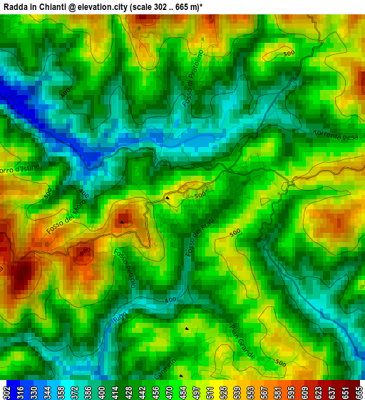
Below is the Elevation map of Radda in Chianti, which displays elevation range with different colors. Scale of the first map is from 302 to 665 m (991 to 2182 ft) with average elevation of 458.9 meters (=1506 ft) [note 1]
These maps also provides idea of topography and contour of this city, they are displayed at different zoom levels. More info about maps, scale and edge coordinates you can find below images.
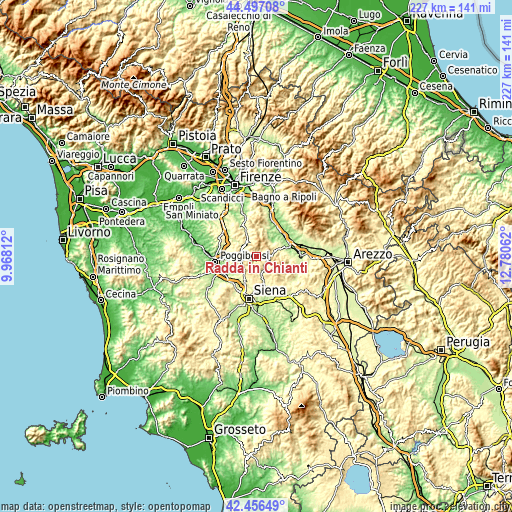
| \ | Map #1 | Topo.Map |
| Scale [m] | 302..665 m | × |
| Scale [ft] | 991..2182 ft | × |
| Average | 458.9 m = 1506 ft | × |
| Width | 7.09 km = 4.4 mi | 226.9 km = 141 mi |
| Height | 7.09 km = 4.4 mi | 226.9 km = 141 mi |
| ↑Max Latitude | 43.517276° | 44.49708° |
| Latitude at center | 43.4854° | 43.4854° |
| ↓Min Latitude | 43.453507° | 42.45649° |
| ← Min Longitude | 11.330425° | 9.96812° |
| Longitude center | 11.37437° | 11.37437° |
| →Max Longitude | 11.418315° | 12.78062° |
Nearby cities:
Cities around Radda in Chianti sort by population:
• San Giovanni Valdarno elevation 135 m
15.5 km,  53°
53°
• Greve in Chianti 240 m
12 km,  337°
337°
• Castellina Scalo 201 m
16.1 km,  236°
236°
• Cavriglia-Monastero 286 m
9.9 km,  66°
66°
• San Cipriano-S.Barbara-Centinale 142 m
12.8 km,  43°
43°
• Castellina in Chianti 561 m
7.2 km,  251°
251°
• Castelnuovo dei Sabbioni 290 m
8.8 km, 45°
• Belverde 333 m
16.2 km,  199°
199°
• Panzano in Chianti 455 m
8.1 km,  323°
323°
• Gaiole in Chianti 351 m
5.2 km,  113°
113°
• Vacchereccia 145 m
13.2 km, 50°
• Monteriggioni 272 m
16.2 km,  228°
228°
Multilingual:
 En español:
Radda in Chianti elevación 498 m.
 En France:
Radda in Chianti élévation 498 m.
 Auf Deutsch:
Radda in Chianti höhe über dem Meeresspiegel ist 498 m.

Sources and notes:
- [note 1] Map square and city borders are not equal. Map elevation data is calculated only from area inside that square.
- [src 1] Elevation data from geonames database provided with same terms of usage.
- [src 2] The elevation map of Radda in Chianti is generated using elevation data from NASA's 3 arcsec (90m) resolution SRTM data.
- [src 3] Base (background) map © OpenStreetMap contributors tiles are generated by Geofabrik and OpenTopoMap.
Copyright & License:
This Radda in Chianti Elevation Map is licensed under CC BY-SA. You may reuse any part from this page, if you give a proper credit by linking to this URL:
 More info on terms of use page.