Re elevation
Re (Piedmont, Provincia Verbano-Cusio-Ossola), Italy elevation is 706 meters and Re elevation in feet is 2316 ft above sea level [src 1]. Re is a seat of a third-order administrative division (feature code) with elevation that is 384 meters (1260 ft) bigger than average city elevation in Italy.
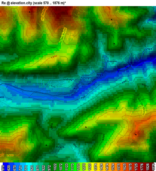
Below is the Elevation map of Re, which displays elevation range with different colors. Scale of the first map is from 570 to 1876 m (1870 to 6155 ft) with average elevation of 1081.8 meters (=3549 ft) [note 1]
These maps also provides idea of topography and contour of this city, they are displayed at different zoom levels. More info about maps, scale and edge coordinates you can find below images.
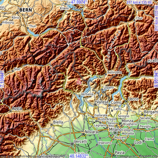
| \ | Map #1 | Topo.Map |
| Scale [m] | 570..1876 m | × |
| Scale [ft] | 1870..6155 ft | × |
| Average | 1081.8 m = 3549 ft | × |
| Width | 6.77 km = 4.2 mi | 216.7 km = 134.7 mi |
| Height | 6.77 km = 4.2 mi | 216.7 km = 134.7 mi |
| ↑Max Latitude | 46.161926° | 47.0974° |
| Latitude at center | 46.13148° | 46.13148° |
| ↓Min Latitude | 46.101017° | 45.14832° |
| ← Min Longitude | 8.501745° | 7.13944° |
| Longitude center | 8.54569° | 8.54569° |
| →Max Longitude | 8.589635° | 9.95194° |
Nearby cities:
Cities around Re sort by population:
• Cannobio elevation 217 m
13.9 km,  123°
123°
• Malesco 756 m
3.7 km,  263°
263°
• Santa Maria Maggiore 832 m
6.5 km,  275°
275°
• Toceno 961 m
6.1 km, 283°
• Druogno 831 m
8.7 km,  271°
271°
• Craveggia 898 m
4.5 km, 283°
• Cavaglio-Spoccia 685 m
9.4 km,  135°
135°
• Villette 818 m
0.9 km, 272°
• Gurro 819 m
5.4 km,  161°
161°
• Trarego 757 m
14.4 km, 138°
• Falmenta 740 m
7.3 km,  152°
152°
• Cursolo 876 m
4 km, 154°
Multilingual:
 En español:
Re elevación 706 m.
 En France:
Re élévation 706 m.


Sources and notes:
- [note 1] Map square and city borders are not equal. Map elevation data is calculated only from area inside that square.
- [src 1] Elevation data from geonames database provided with same terms of usage.
- [src 2] The elevation map of Re is generated using elevation data from NASA's 3 arcsec (90m) resolution SRTM data.
- [src 3] Base (background) map © OpenStreetMap contributors tiles are generated by Geofabrik and OpenTopoMap.
Copyright & License:
This Re Elevation Map is licensed under CC BY-SA. You may reuse any part from this page, if you give a proper credit by linking to this URL:
 More info on terms of use page.