Trarego elevation
Trarego (Piedmont, Provincia Verbano-Cusio-Ossola), Italy elevation is 757 meters and Trarego elevation in feet is 2484 ft above sea level [src 1]. Trarego is a seat of a third-order administrative division (feature code) with elevation that is 435 meters (1427 ft) bigger than average city elevation in Italy.
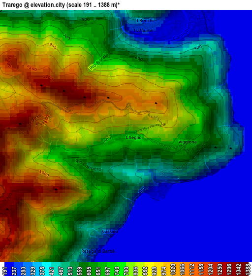
Below is the Elevation map of Trarego, which displays elevation range with different colors. Scale of the first map is from 191 to 1388 m (627 to 4554 ft) with average elevation of 636.7 meters (=2089 ft) [note 1]
These maps also provides idea of topography and contour of this city, they are displayed at different zoom levels. More info about maps, scale and edge coordinates you can find below images.
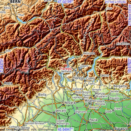
| \ | Map #1 | Topo.Map |
| Scale [m] | 191..1388 m | × |
| Scale [ft] | 627..4554 ft | × |
| Average | 636.7 m = 2089 ft | × |
| Width | 6.78 km = 4.2 mi | 217.1 km = 134.9 mi |
| Height | 6.78 km = 4.2 mi | 217.1 km = 134.9 mi |
| ↑Max Latitude | 46.06485° | 47.00199° |
| Latitude at center | 46.03435° | 46.03435° |
| ↓Min Latitude | 46.003834° | 45.04947° |
| ← Min Longitude | 8.626035° | 7.26373° |
| Longitude center | 8.66998° | 8.66998° |
| →Max Longitude | 8.713925° | 10.07623° |
Nearby cities:
Cities around Trarego sort by population:
• Luino elevation 209 m
6.8 km,  121°
121°
• Cannobio 217 m
3.7 km,  33°
33°
• Germignaga 211 m
6.4 km,  138°
138°
• Maccagno 203 m
5.1 km,  78°
78°
• Brezzo di Bedero 344 m
7.2 km,  149°
149°
• Cannero Riviera 228 m
1.6 km, 152°
• Oggebbio 230 m
5.2 km,  200°
200°
• Bedero 344 m
7.3 km, 149°
• Gonte 291 m
4.6 km, 199°
• Agra 651 m
7.6 km,  88°
88°
• Cavaglio-Spoccia 685 m
5.1 km,  323°
323°
• Aurano 726 m
7.4 km,  239°
239°
Multilingual:
 En español:
Trarego elevación 757 m.
 En France:
Trarego élévation 757 m.


Sources and notes:
- [note 1] Map square and city borders are not equal. Map elevation data is calculated only from area inside that square.
- [src 1] Elevation data from geonames database provided with same terms of usage.
- [src 2] The elevation map of Trarego is generated using elevation data from NASA's 3 arcsec (90m) resolution SRTM data.
- [src 3] Base (background) map © OpenStreetMap contributors tiles are generated by Geofabrik and OpenTopoMap.
Copyright & License:
This Trarego Elevation Map is licensed under CC BY-SA. You may reuse any part from this page, if you give a proper credit by linking to this URL:
 More info on terms of use page.