Germignaga elevation
Germignaga (Lombardy, Provincia di Varese), Italy elevation is 211 meters and Germignaga elevation in feet is 692 ft above sea level [src 1]. Germignaga is a seat of a third-order administrative division (feature code) with elevation that is 111 meters (364 ft) smaller than average city elevation in Italy.
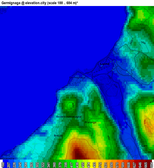
Below is the Elevation map of Germignaga, which displays elevation range with different colors. Scale of the first map is from 188 to 684 m (617 to 2244 ft) with average elevation of 258 meters (=846 ft) [note 1]
These maps also provides idea of topography and contour of this city, they are displayed at different zoom levels. More info about maps, scale and edge coordinates you can find below images.
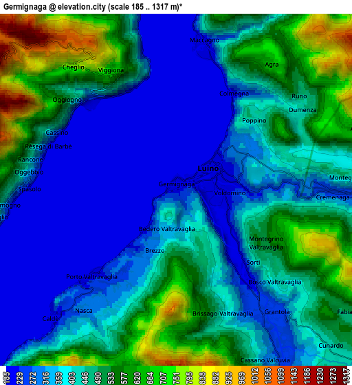
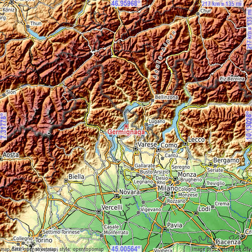
| \ | Map #1 | Map #2 | Topo.Map |
| Scale [m] | 188..684 m | 185..1317 m | × |
| Scale [ft] | 617..2244 ft | 607..4321 ft | × |
| Average | 258 m = 846 ft | 430.9 m = 1414 ft | × |
| Width | 6.79 km = 4.2 mi | 13.58 km = 8.4 mi | 217.3 km = 135 mi |
| Height | 6.79 km = 4.2 mi | 13.58 km = 8.4 mi | 217.3 km = 135 mi |
| ↑Max Latitude | 46.021803° | 46.05231° | 46.95968° |
| Latitude at center | 45.99128° | 45.99128° | 45.99128° |
| ↓Min Latitude | 45.96074° | 45.930183° | 45.00564° |
| ← Min Longitude | 8.680085° | 8.636139° | 7.31778° |
| Longitude center | 8.72403° | 8.72403° | 8.72403° |
| →Max Longitude | 8.767975° | 8.811921° | 10.13028° |
Nearby cities:
Cities around Germignaga sort by population:
• Luino elevation 209 m
2 km,  54°
54°
• Porto Valtravaglia 211 m
4.7 km,  224°
224°
• Castello 301 m
5.9 km, 219°
• Maccagno 203 m
5.9 km,  7°
7°
• Mesenzana 243 m
5.4 km,  144°
144°
• Brezzo di Bedero 344 m
1.5 km,  199°
199°
• Cannero Riviera 228 m
4.9 km,  314°
314°
• Dumenza 420 m
5.9 km,  55°
55°
• Bedero 344 m
1.6 km, 195°
• Gonte 291 m
5.7 km,  274°
274°
• Brissago-Valtravaglia 425 m
5 km,  160°
160°
• Montegrino Valtravaglia 520 m
3.9 km,  119°
119°
Multilingual:
 En español:
Germignaga elevación 211 m.
 En France:
Germignaga élévation 211 m.
 Auf Deutsch:
Germignaga höhe über dem Meeresspiegel ist 211 m.

Sources and notes:
- [note 1] Map square and city borders are not equal. Map elevation data is calculated only from area inside that square.
- [src 1] Elevation data from geonames database provided with same terms of usage.
- [src 2] The elevation map of Germignaga is generated using elevation data from NASA's 3 arcsec (90m) resolution SRTM data.
- [src 3] Base (background) map © OpenStreetMap contributors tiles are generated by Geofabrik and OpenTopoMap.
Copyright & License:
This Germignaga Elevation Map is licensed under CC BY-SA. You may reuse any part from this page, if you give a proper credit by linking to this URL:
 More info on terms of use page.