Robilante elevation
Robilante (Piedmont, Provincia di Cuneo), Italy elevation is 682 meters and Robilante elevation in feet is 2238 ft above sea level [src 1]. Robilante is a seat of a third-order administrative division (feature code) with elevation that is 360 meters (1181 ft) bigger than average city elevation in Italy.
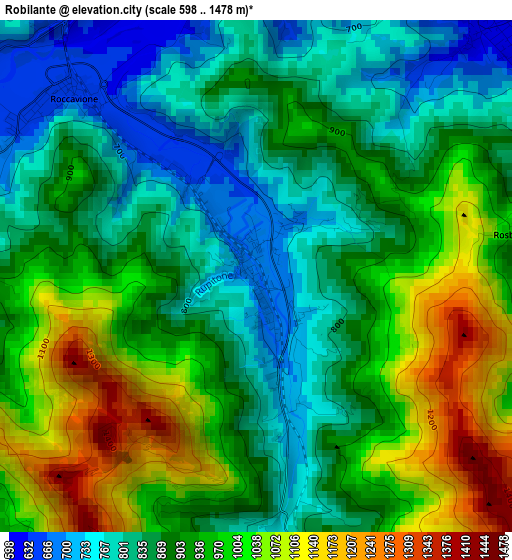
Below is the Elevation map of Robilante, which displays elevation range with different colors. Scale of the first map is from 598 to 1478 m (1962 to 4849 ft) with average elevation of 911.7 meters (=2991 ft) [note 1]
These maps also provides idea of topography and contour of this city, they are displayed at different zoom levels. More info about maps, scale and edge coordinates you can find below images.
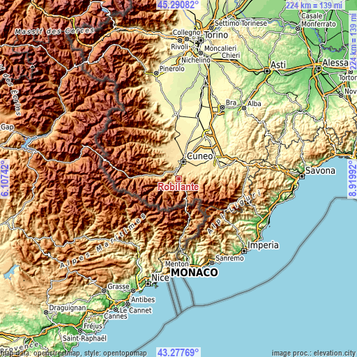
| \ | Map #1 | Topo.Map |
| Scale [m] | 598..1478 m | × |
| Scale [ft] | 1962..4849 ft | × |
| Average | 911.7 m = 2991 ft | × |
| Width | 6.99 km = 4.3 mi | 223.8 km = 139.1 mi |
| Height | 7 km = 4.3 mi | 223.8 km = 139.1 mi |
| ↑Max Latitude | 44.324327° | 45.29082° |
| Latitude at center | 44.29288° | 44.29288° |
| ↓Min Latitude | 44.261416° | 43.27769° |
| ← Min Longitude | 7.469725° | 6.10742° |
| Longitude center | 7.51367° | 7.51367° |
| →Max Longitude | 7.557615° | 8.91992° |
Nearby cities:
Cities around Robilante sort by population:
• Borgo San Dalmazzo elevation 630 m
5.3 km,  341°
341°
• Boves 587 m
4.9 km,  33°
33°
• Peveragno 630 m
8.9 km,  69°
69°
• Roccavione 656 m
3.6 km,  309°
309°
• Vignolo 619 m
8.5 km, 337°
• Cervasca 580 m
10.4 km, 340°
• Vernante 793 m
5.6 km,  162°
162°
• Valdieri 786 m
9.4 km,  259°
259°
• Gaiola 693 m
9.6 km,  299°
299°
• Roccasparvera 674 m
7.9 km, 313°
• Moiola 691 m
10.3 km,  287°
287°
• Roaschia 811 m
5.3 km,  241°
241°
Multilingual:
 En español:
Robilante elevación 682 m.
 En France:
Robilante élévation 682 m.
 Auf Deutsch:
Robilante höhe über dem Meeresspiegel ist 682 m.

Sources and notes:
- [note 1] Map square and city borders are not equal. Map elevation data is calculated only from area inside that square.
- [src 1] Elevation data from geonames database provided with same terms of usage.
- [src 2] The elevation map of Robilante is generated using elevation data from NASA's 3 arcsec (90m) resolution SRTM data.
- [src 3] Base (background) map © OpenStreetMap contributors tiles are generated by Geofabrik and OpenTopoMap.
Copyright & License:
This Robilante Elevation Map is licensed under CC BY-SA. You may reuse any part from this page, if you give a proper credit by linking to this URL:
 More info on terms of use page.