Salcedo elevation
Salcedo (Veneto, Provincia di Vicenza), Italy elevation is 387 meters and Salcedo elevation in feet is 1270 ft above sea level [src 1]. Salcedo is a seat of a third-order administrative division (feature code) with elevation that is 65 meters (213 ft) bigger than average city elevation in Italy.
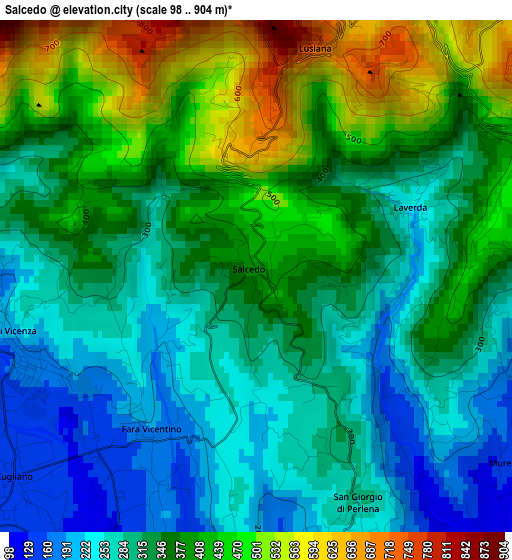
Below is the Elevation map of Salcedo, which displays elevation range with different colors. Scale of the first map is from 98 to 904 m (322 to 2966 ft) with average elevation of 352.4 meters (=1156 ft) [note 1]
These maps also provides idea of topography and contour of this city, they are displayed at different zoom levels. More info about maps, scale and edge coordinates you can find below images.
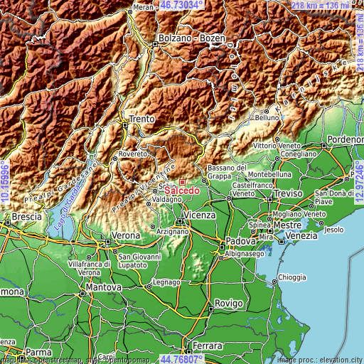
| \ | Map #1 | Topo.Map |
| Scale [m] | 98..904 m | × |
| Scale [ft] | 322..2966 ft | × |
| Average | 352.4 m = 1156 ft | × |
| Width | 6.82 km = 4.2 mi | 218.2 km = 135.6 mi |
| Height | 6.82 km = 4.2 mi | 218.2 km = 135.6 mi |
| ↑Max Latitude | 45.788482° | 46.73034° |
| Latitude at center | 45.75783° | 45.75783° |
| ↓Min Latitude | 45.727161° | 44.76807° |
| ← Min Longitude | 11.522265° | 10.15996° |
| Longitude center | 11.56621° | 11.56621° |
| →Max Longitude | 11.610155° | 12.97246° |
Nearby cities:
Cities around Salcedo sort by population:
• Breganze elevation 108 m
5.9 km,  184°
184°
• Sarcedo 112 m
6.9 km,  204°
204°
• Zugliano 145 m
4.5 km,  226°
226°
• Lugo di Vicenza 165 m
3.2 km,  244°
244°
• Mason Vicentino 105 m
5.4 km,  144°
144°
• Fara Vicentino 212 m
2.3 km, 225°
• Grumolo Pedemonte 154 m
6.8 km, 236°
• Calvene 197 m
4.3 km,  282°
282°
• Conco 842 m
5.8 km,  35°
35°
• Pianezze 162 m
5.1 km,  111°
111°
• Mure 116 m
4.3 km,  127°
127°
• Lusiana 725 m
3 km,  12°
12°
Multilingual:
 En español:
Salcedo elevación 387 m.
 En France:
Salcedo élévation 387 m.


Sources and notes:
- [note 1] Map square and city borders are not equal. Map elevation data is calculated only from area inside that square.
- [src 1] Elevation data from geonames database provided with same terms of usage.
- [src 2] The elevation map of Salcedo is generated using elevation data from NASA's 3 arcsec (90m) resolution SRTM data.
- [src 3] Base (background) map © OpenStreetMap contributors tiles are generated by Geofabrik and OpenTopoMap.
Copyright & License:
This Salcedo Elevation Map is licensed under CC BY-SA. You may reuse any part from this page, if you give a proper credit by linking to this URL:
 More info on terms of use page.