San Candido elevation
San Candido (Trentino-Alto Adige, Bolzano), Italy elevation is 1177 meters and San Candido elevation in feet is 3862 ft above sea level [src 1]. San Candido is a seat of a third-order administrative division (feature code) with elevation that is 855 meters (2805 ft) bigger than average city elevation in Italy.
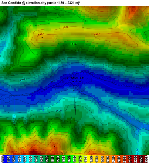
Below is the Elevation map of San Candido, which displays elevation range with different colors. Scale of the first map is from 1139 to 2321 m (3737 to 7615 ft) with average elevation of 1536.5 meters (=5041 ft) [note 1]
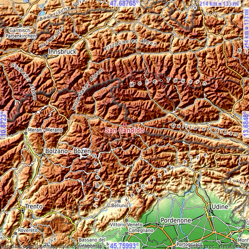
These maps also provides idea of topography and contour of this city, they are displayed at different zoom levels. More info about maps, scale and edge coordinates you can find below images.
| \ | Map #1 | Topo.Map |
| Scale [m] | 1139..2321 m | × |
| Scale [ft] | 3737..7615 ft | × |
| Average | 1536.5 m = 5041 ft | × |
| Width | 6.7 km = 4.2 mi | 214.3 km = 133.2 mi |
| Height | 6.7 km = 4.2 mi | 214.3 km = 133.2 mi |
| ↑Max Latitude | 46.762512° | 47.68765° |
| Latitude at center | 46.7324° | 46.7324° |
| ↓Min Latitude | 46.702271° | 45.75993° |
| ← Min Longitude | 12.234605° | 10.8723° |
| Longitude center | 12.27855° | 12.27855° |
| →Max Longitude | 12.322495° | 13.6848° |
Nearby cities:
Cities around San Candido sort by population:
• Auronzo elevation 887 m
22.3 km,  149°
149°
• Rasun Anterselva - Rasen-Antholz 1019 m
18.3 km,  286°
286°
• Dobbiaco 1217 m
4.3 km,  264°
264°
• Valle di Casies - Gsies 1206 m
8.5 km,  297°
297°
• Valdaora di Mezzo 1052 m
19.2 km,  279°
279°
• Monguelfo 1093 m
13.5 km, 282°
• Villabassa 1153 m
8.1 km,  274°
274°
• Sesto 1309 m
6.4 km,  121°
121°
• Candide 1215 m
24.1 km,  131°
131°
• Perca 1010 m
23.5 km, 286°
• Braies 1214 m
11.1 km, 263°
• San Martino 1279 m
9.6 km,  335°
335°
Multilingual:
 En español:
San Candido elevación 1177 m.
 En France:
San Candido élévation 1177 m.
 Auf Deutsch:
Innichen höhe über dem Meeresspiegel ist 1177 m.

Sources and notes:
- [note 1] Map square and city borders are not equal. Map elevation data is calculated only from area inside that square.
- [src 1] Elevation data from geonames database provided with same terms of usage.
- [src 2] The elevation map of San Candido is generated using elevation data from NASA's 3 arcsec (90m) resolution SRTM data.
- [src 3] Base (background) map © OpenStreetMap contributors tiles are generated by Geofabrik and OpenTopoMap.
Copyright & License:
This San Candido Elevation Map is licensed under CC BY-SA. You may reuse any part from this page, if you give a proper credit by linking to this URL:
 More info on terms of use page.