Sesto elevation
Sesto (Trentino-Alto Adige, Bolzano), Italy elevation is 1309 meters and Sesto elevation in feet is 4295 ft above sea level [src 1]. Sesto is a seat of a third-order administrative division (feature code) with elevation that is 987 meters (3238 ft) bigger than average city elevation in Italy.
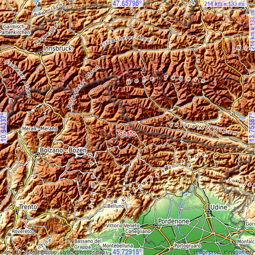
Below is the Elevation map of Sesto, which displays elevation range with different colors. Scale of the first map is from 1130 to 2801 m (3707 to 9190 ft) with average elevation of 1651 meters (=5417 ft) [note 1]
These maps also provides idea of topography and contour of this city, they are displayed at different zoom levels. More info about maps, scale and edge coordinates you can find below images.

| \ | Map #1 | Topo.Map |
| Scale [m] | 1130..2801 m | × |
| Scale [ft] | 3707..9190 ft | × |
| Average | 1651 m = 5417 ft | × |
| Width | 6.7 km = 4.2 mi | 214.5 km = 133.3 mi |
| Height | 6.7 km = 4.2 mi | 214.4 km = 133.2 mi |
| ↑Max Latitude | 46.732289° | 47.65795° |
| Latitude at center | 46.70216° | 46.70216° |
| ↓Min Latitude | 46.672014° | 45.72915° |
| ← Min Longitude | 12.305675° | 10.94337° |
| Longitude center | 12.34962° | 12.34962° |
| →Max Longitude | 12.393565° | 13.75587° |
Nearby cities:
Cities around Sesto sort by population:
• Auronzo elevation 887 m
16.9 km,  160°
160°
• Dobbiaco 1217 m
10.2 km,  286°
286°
• San Candido 1177 m
6.4 km,  301°
301°
• Valle di Casies - Gsies 1206 m
14.9 km, 299°
• Monguelfo 1093 m
19.6 km, 288°
• Villabassa 1153 m
14.1 km, 286°
• Santo Stefano di Cadore 913 m
22.1 km,  136°
136°
• Candide 1215 m
17.8 km,  134°
134°
• Braies 1214 m
16.6 km,  276°
276°
• Danta 1379 m
19.9 km, 139°
• San Martino 1279 m
15.3 km,  322°
322°
• San Nicolò Comelico 1064 m
19 km, 134°
Multilingual:
 En español:
Sesto elevación 1309 m.
 En France:
Sesto élévation 1309 m.


Sources and notes:
- [note 1] Map square and city borders are not equal. Map elevation data is calculated only from area inside that square.
- [src 1] Elevation data from geonames database provided with same terms of usage.
- [src 2] The elevation map of Sesto is generated using elevation data from NASA's 3 arcsec (90m) resolution SRTM data.
- [src 3] Base (background) map © OpenStreetMap contributors tiles are generated by Geofabrik and OpenTopoMap.
Copyright & License:
This Sesto Elevation Map is licensed under CC BY-SA. You may reuse any part from this page, if you give a proper credit by linking to this URL:
 More info on terms of use page.