San Giovanni Rotondo elevation
San Giovanni Rotondo (Apulia, Provincia di Foggia), Italy elevation is 570 meters and San Giovanni Rotondo elevation in feet is 1870 ft above sea level [src 1]. San Giovanni Rotondo is a seat of a third-order administrative division (feature code) with elevation that is 248 meters (814 ft) bigger than average city elevation in Italy.
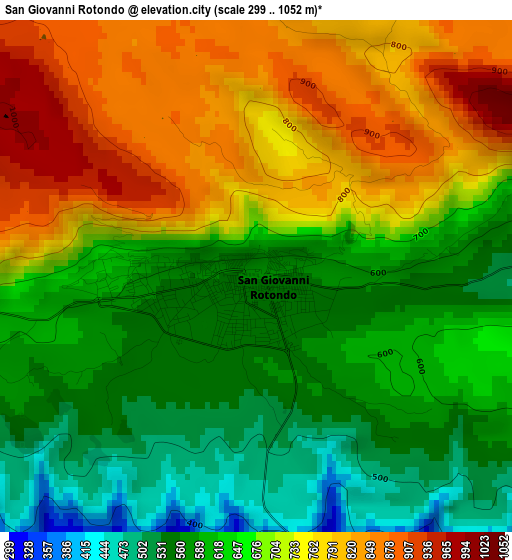
Below is the Elevation map of San Giovanni Rotondo, which displays elevation range with different colors. Scale of the first map is from 299 to 1052 m (981 to 3451 ft) with average elevation of 670.9 meters (=2201 ft) [note 1]
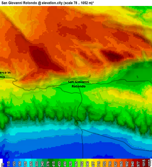
These maps also provides idea of topography and contour of this city, they are displayed at different zoom levels. More info about maps, scale and edge coordinates you can find below images.
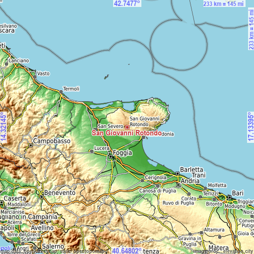
| \ | Map #1 | Map #2 | Topo.Map |
| Scale [m] | 299..1052 m | 78..1052 m | × |
| Scale [ft] | 981..3451 ft | 256..3451 ft | × |
| Average | 670.9 m = 2201 ft | 590.2 m = 1936 ft | × |
| Width | 7.3 km = 4.5 mi | 14.59 km = 9.1 mi | 233.5 km = 145.1 mi |
| Height | 7.3 km = 4.5 mi | 14.59 km = 9.1 mi | 233.5 km = 145.1 mi |
| ↑Max Latitude | 41.73923° | 41.772012° | 42.7477° |
| Latitude at center | 41.70643° | 41.70643° | 41.70643° |
| ↓Min Latitude | 41.673614° | 41.640781° | 40.64802° |
| ← Min Longitude | 15.683755° | 15.639809° | 14.32145° |
| Longitude center | 15.7277° | 15.7277° | 15.7277° |
| →Max Longitude | 15.771645° | 15.815591° | 17.13395° |
Nearby cities:
Cities around San Giovanni Rotondo sort by population:
• Manfredonia elevation 19 m
18 km,  117°
117°
• Sannicandro Garganico 217 m
19.9 km,  317°
317°
• San Marco in Lamis 559 m
7.5 km,  274°
274°
• Apricena 74 m
25.2 km,  290°
290°
• Monte Sant'Angelo 774 m
19.3 km,  90°
90°
• Cagnano Varano 156 m
14 km,  15°
15°
• Vico del Gargano 447 m
28.4 km,  41°
41°
• Mattinata 84 m
26.8 km, 88°
• Carpino 142 m
18.7 km,  34°
34°
• Ischitella 326 m
26.2 km, 32°
• Rodi Garganico 62 m
27.7 km, 27°
• Rignano Garganico 579 m
12 km,  255°
255°
Multilingual:
 En español:
San Giovanni Rotondo elevación 570 m.
 En France:
San Giovanni Rotondo élévation 570 m.
 Auf Deutsch:
San Giovanni Rotondo höhe über dem Meeresspiegel ist 570 m.
 На русском:
San Giovanni Rotondo высота над уровнем моря 570 м
Sources and notes:
- [note 1] Map square and city borders are not equal. Map elevation data is calculated only from area inside that square.
- [src 1] Elevation data from geonames database provided with same terms of usage.
- [src 2] The elevation map of San Giovanni Rotondo is generated using elevation data from NASA's 3 arcsec (90m) resolution SRTM data.
- [src 3] Base (background) map © OpenStreetMap contributors tiles are generated by Geofabrik and OpenTopoMap.
Copyright & License:
This San Giovanni Rotondo Elevation Map is licensed under CC BY-SA. You may reuse any part from this page, if you give a proper credit by linking to this URL:
 More info on terms of use page.