San Martino in Campo elevation
San Martino in Campo (Umbria, Provincia di Perugia), Italy elevation is 176 meters and San Martino in Campo elevation in feet is 577 ft above sea level [src 1]. San Martino in Campo is a populated place (feature code) with elevation that is 146 meters (479 ft) smaller than average city elevation in Italy.
Below is the Elevation map of San Martino in Campo, which displays elevation range with different colors. Scale of the first map is from 160 to 340 m (525 to 1115 ft) with average elevation of 198 meters (=650 ft) [note 1]
These maps also provides idea of topography and contour of this city, they are displayed at different zoom levels. More info about maps, scale and edge coordinates you can find below images.
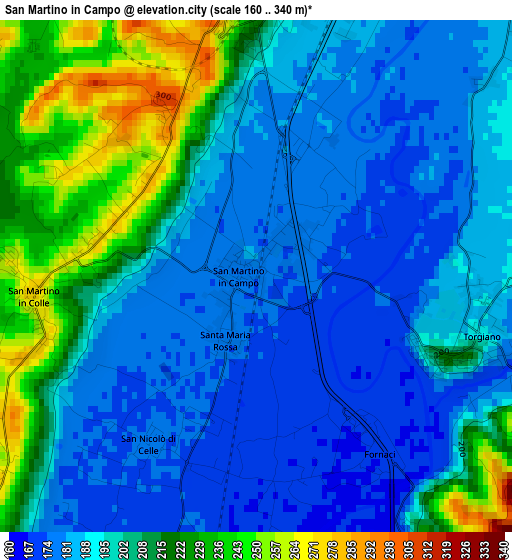
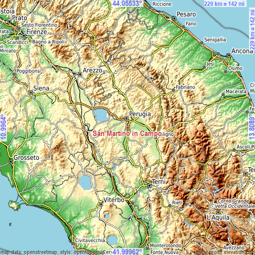
| \ | Map #1 | Topo.Map |
| Scale [m] | 160..340 m | × |
| Scale [ft] | 525..1115 ft | × |
| Average | 198 m = 650 ft | × |
| Width | 7.14 km = 4.4 mi | 228.6 km = 142 mi |
| Height | 7.14 km = 4.4 mi | 228.6 km = 142 mi |
| ↑Max Latitude | 43.068192° | 44.05533° |
| Latitude at center | 43.03608° | 43.03608° |
| ↓Min Latitude | 43.003951° | 41.99962° |
| ← Min Longitude | 12.358705° | 10.9964° |
| Longitude center | 12.40265° | 12.40265° |
| →Max Longitude | 12.446595° | 13.8089° |
Nearby cities:
Cities around San Martino in Campo sort by population:
• Perugia elevation 482 m
8.5 km,  352°
352°
• Chiugiana-La Commenda 247 m
10.3 km,  312°
312°
• Deruta 168 m
5.8 km,  167°
167°
• Torgiano 200 m
3.2 km,  107°
107°
• Pila 290 m
6.3 km,  287°
287°
• Via Lippia 216 m
8.5 km,  48°
48°
• Ospedalicchio 199 m
9.2 km,  59°
59°
• Lacugnano 322 m
8.7 km,  318°
318°
• Passaggio 188 m
8.7 km,  100°
100°
• San Niccolò di Celle 174 m
2.7 km,  216°
216°
• Bettona 348 m
7.4 km, 111°
• bishopric of Perugia 395 m
8.6 km, 352°
Multilingual:
 En español:
San Martino in Campo elevación 176 m.
 En France:
San Martino in Campo élévation 176 m.
 Auf Deutsch:
San Martino in Campo höhe über dem Meeresspiegel ist 176 m.
 На русском:
San Martino in Campo высота над уровнем моря 176 м
Sources and notes:
- [note 1] Map square and city borders are not equal. Map elevation data is calculated only from area inside that square.
- [src 1] Elevation data from geonames database provided with same terms of usage.
- [src 2] The elevation map of San Martino in Campo is generated using elevation data from NASA's 3 arcsec (90m) resolution SRTM data.
- [src 3] Base (background) map © OpenStreetMap contributors tiles are generated by Geofabrik and OpenTopoMap.
Copyright & License:
This San Martino in Campo Elevation Map is licensed under CC BY-SA. You may reuse any part from this page, if you give a proper credit by linking to this URL:
 More info on terms of use page.