Sant'Arcangelo elevation
Sant'Arcangelo (Basilicate, Provincia di Potenza), Italy elevation is 338 meters and Sant'Arcangelo elevation in feet is 1109 ft above sea level [src 1]. Sant'Arcangelo is a seat of a third-order administrative division (feature code) with elevation that is 16 meters (52 ft) bigger than average city elevation in Italy.
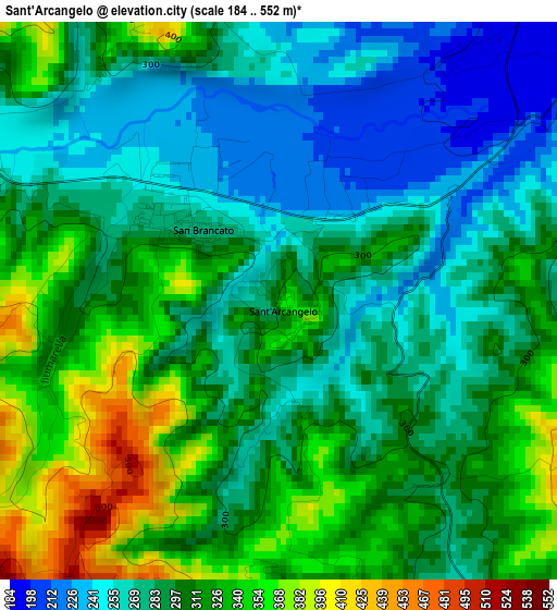
Below is the Elevation map of Sant'Arcangelo, which displays elevation range with different colors. Scale of the first map is from 184 to 552 m (604 to 1811 ft) with average elevation of 298.1 meters (=978 ft) [note 1]
These maps also provides idea of topography and contour of this city, they are displayed at different zoom levels. More info about maps, scale and edge coordinates you can find below images.
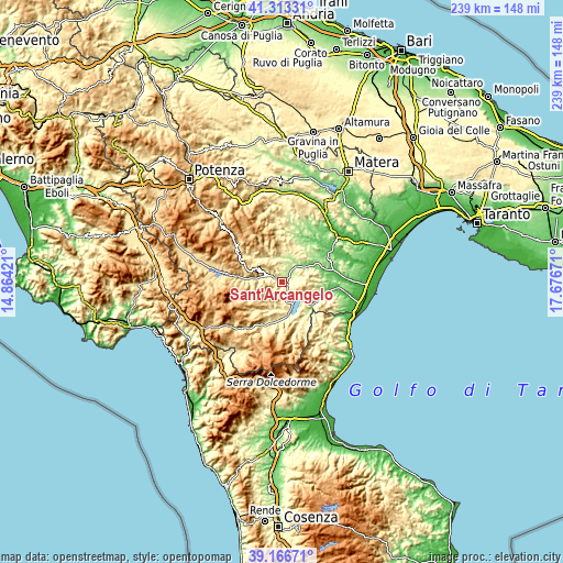
| \ | Map #1 | Topo.Map |
| Scale [m] | 184..552 m | × |
| Scale [ft] | 604..1811 ft | × |
| Average | 298.1 m = 978 ft | × |
| Width | 7.46 km = 4.6 mi | 238.7 km = 148.3 mi |
| Height | 7.46 km = 4.6 mi | 238.7 km = 148.3 mi |
| ↑Max Latitude | 40.282053° | 41.31331° |
| Latitude at center | 40.24852° | 40.24852° |
| ↓Min Latitude | 40.21497° | 39.16671° |
| ← Min Longitude | 16.226515° | 14.86421° |
| Longitude center | 16.27046° | 16.27046° |
| →Max Longitude | 16.314405° | 17.67671° |
Nearby cities:
Cities around Sant'Arcangelo sort by population:
• Senise elevation 350 m
11.5 km,  172°
172°
• Tursi 188 m
17.1 km,  90°
90°
• San Brancato 268 m
1.6 km,  312°
312°
• Colobraro 618 m
14.7 km,  117°
117°
• Chiaromonte 736 m
14.7 km,  198°
198°
• Roccanova 667 m
6.9 km,  234°
234°
• Gallicchio 764 m
12.4 km,  293°
293°
• Aliano 543 m
8 km,  334°
334°
• Castronuovo di Sant'Andrea 690 m
9.8 km, 227°
• Teana 781 m
16.9 km,  216°
216°
• Missanello 623 m
9.6 km, 293°
• Calvera 616 m
15.5 km, 224°
Multilingual:
 En español:
Sant'Arcangelo elevación 338 m.
 En France:
Sant'Arcangelo élévation 338 m.
 Auf Deutsch:
Sant'Arcangelo höhe über dem Meeresspiegel ist 338 m.

Sources and notes:
- [note 1] Map square and city borders are not equal. Map elevation data is calculated only from area inside that square.
- [src 1] Elevation data from geonames database provided with same terms of usage.
- [src 2] The elevation map of Sant'Arcangelo is generated using elevation data from NASA's 3 arcsec (90m) resolution SRTM data.
- [src 3] Base (background) map © OpenStreetMap contributors tiles are generated by Geofabrik and OpenTopoMap.
Copyright & License:
This Sant'Arcangelo Elevation Map is licensed under CC BY-SA. You may reuse any part from this page, if you give a proper credit by linking to this URL:
 More info on terms of use page.