San Vito elevation
San Vito (Emilia-Romagna, Provincia di Modena), Italy elevation is 57 meters and San Vito elevation in feet is 187 ft above sea level [src 1]. San Vito is a populated place (feature code) with elevation that is 265 meters (869 ft) smaller than average city elevation in Italy.
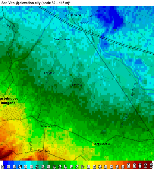
Below is the Elevation map of San Vito, which displays elevation range with different colors. Scale of the first map is from 32 to 115 m (105 to 377 ft) with average elevation of 58.1 meters (=191 ft) [note 1]
These maps also provides idea of topography and contour of this city, they are displayed at different zoom levels. More info about maps, scale and edge coordinates you can find below images.
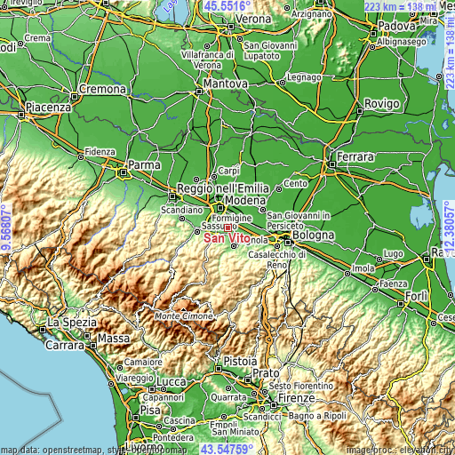
| \ | Map #1 | Topo.Map |
| Scale [m] | 32..115 m | × |
| Scale [ft] | 105..377 ft | × |
| Average | 58.1 m = 191 ft | × |
| Width | 6.96 km = 4.3 mi | 222.8 km = 138.4 mi |
| Height | 6.96 km = 4.3 mi | 222.8 km = 138.4 mi |
| ↑Max Latitude | 44.589524° | 45.5516° |
| Latitude at center | 44.55822° | 44.55822° |
| ↓Min Latitude | 44.526899° | 43.54759° |
| ← Min Longitude | 10.930375° | 9.56807° |
| Longitude center | 10.97432° | 10.97432° |
| →Max Longitude | 11.018265° | 12.38057° |
Nearby cities:
Cities around San Vito sort by population:
• Castelfranco Emilia elevation 44 m
7.2 km,  56°
56°
• Spilamberto 69 m
4.4 km,  129°
129°
• Castelnuovo Rangone 74 m
3.4 km,  253°
253°
• Montale 67 m
5.4 km,  283°
283°
• Piumazzo 58 m
7.5 km,  100°
100°
• Castelvetro di Modena 120 m
6.4 km,  200°
200°
• San Cesario sul Panaro 55 m
4.8 km,  83°
83°
• Pozza 126 m
7.4 km,  241°
241°
• San Damaso 41 m
4.8 km,  359°
359°
• Solignano Nuovo 118 m
5.1 km,  228°
228°
• Colombaro 91 m
6.2 km,  263°
263°
• Ca' di Sola 92 m
3.5 km,  206°
206°
Multilingual:
 En español:
San Vito elevación 57 m.
 En France:
San Vito élévation 57 m.


Sources and notes:
- [note 1] Map square and city borders are not equal. Map elevation data is calculated only from area inside that square.
- [src 1] Elevation data from geonames database provided with same terms of usage.
- [src 2] The elevation map of San Vito is generated using elevation data from NASA's 3 arcsec (90m) resolution SRTM data.
- [src 3] Base (background) map © OpenStreetMap contributors tiles are generated by Geofabrik and OpenTopoMap.
Copyright & License:
This San Vito Elevation Map is licensed under CC BY-SA. You may reuse any part from this page, if you give a proper credit by linking to this URL:
 More info on terms of use page.