Sanza elevation
Sanza (Campania, Provincia di Salerno), Italy elevation is 536 meters and Sanza elevation in feet is 1759 ft above sea level [src 1]. Sanza is a seat of a third-order administrative division (feature code) with elevation that is 214 meters (702 ft) bigger than average city elevation in Italy.
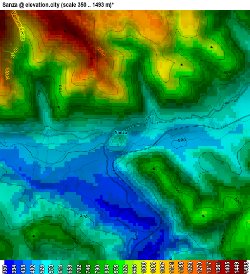
Below is the Elevation map of Sanza, which displays elevation range with different colors. Scale of the first map is from 350 to 1493 m (1148 to 4898 ft) with average elevation of 733.1 meters (=2405 ft) [note 1]
These maps also provides idea of topography and contour of this city, they are displayed at different zoom levels. More info about maps, scale and edge coordinates you can find below images.
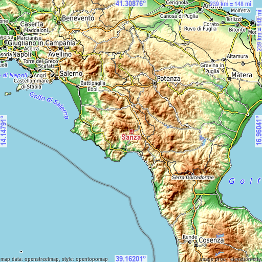
| \ | Map #1 | Topo.Map |
| Scale [m] | 350..1493 m | × |
| Scale [ft] | 1148..4898 ft | × |
| Average | 733.1 m = 2405 ft | × |
| Width | 7.46 km = 4.6 mi | 238.7 km = 148.3 mi |
| Height | 7.46 km = 4.6 mi | 238.7 km = 148.3 mi |
| ↑Max Latitude | 40.277425° | 41.30876° |
| Latitude at center | 40.24389° | 40.24389° |
| ↓Min Latitude | 40.210338° | 39.16201° |
| ← Min Longitude | 15.510215° | 14.14791° |
| Longitude center | 15.55416° | 15.55416° |
| →Max Longitude | 15.598105° | 16.96041° |
Nearby cities:
Cities around Sanza sort by population:
• Padula elevation 604 m
13.7 km,  39°
39°
• Sassano 477 m
10.8 km,  5°
5°
• Buonabitacolo 500 m
6.3 km,  64°
64°
• Rofrano 463 m
11.2 km,  252°
252°
• Caselle in Pittari 415 m
7.9 km,  186°
186°
• Monte San Giacomo 652 m
11.2 km,  354°
354°
• Montesano sulla Marcellana 838 m
13.2 km,  74°
74°
• Alfano 296 m
13.3 km,  235°
235°
• Casalbuono 574 m
11.8 km,  106°
106°
• Casaletto Spartano 407 m
11.7 km,  151°
151°
• Tortorella 580 m
12.1 km,  158°
158°
• Morigerati 290 m
11.5 km,  179°
179°
Multilingual:
 En español:
Sanza elevación 536 m.
 En France:
Sanza élévation 536 m.


Sources and notes:
- [note 1] Map square and city borders are not equal. Map elevation data is calculated only from area inside that square.
- [src 1] Elevation data from geonames database provided with same terms of usage.
- [src 2] The elevation map of Sanza is generated using elevation data from NASA's 3 arcsec (90m) resolution SRTM data.
- [src 3] Base (background) map © OpenStreetMap contributors tiles are generated by Geofabrik and OpenTopoMap.
Copyright & License:
This Sanza Elevation Map is licensed under CC BY-SA. You may reuse any part from this page, if you give a proper credit by linking to this URL:
 More info on terms of use page.