Scandriglia elevation
Scandriglia (Latium, Provincia di Rieti), Italy elevation is 486 meters and Scandriglia elevation in feet is 1594 ft above sea level [src 1]. Scandriglia is a seat of a third-order administrative division (feature code) with elevation that is 164 meters (538 ft) bigger than average city elevation in Italy.
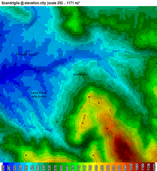
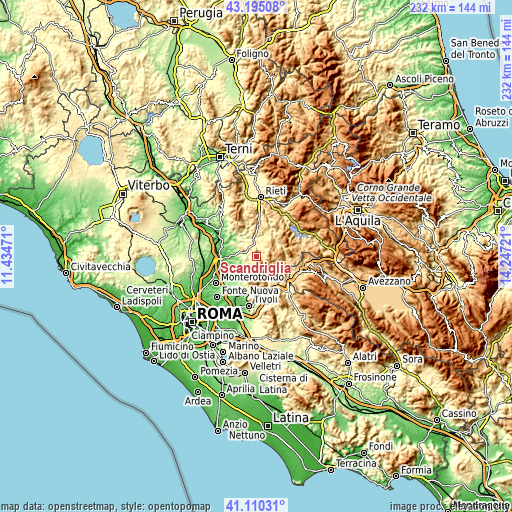
Below is the Elevation map of Scandriglia, which displays elevation range with different colors. Scale of the first map is from 252 to 1171 m (827 to 3842 ft) with average elevation of 519.8 meters (=1705 ft) [note 1]
These maps also provides idea of topography and contour of this city, they are displayed at different zoom levels. More info about maps, scale and edge coordinates you can find below images.
| \ | Map #1 | Topo.Map |
| Scale [m] | 252..1171 m | × |
| Scale [ft] | 827..3842 ft | × |
| Average | 519.8 m = 1705 ft | × |
| Width | 7.24 km = 4.5 mi | 231.8 km = 144 mi |
| Height | 7.24 km = 4.5 mi | 231.8 km = 144 mi |
| ↑Max Latitude | 42.193846° | 43.19508° |
| Latitude at center | 42.16128° | 42.16128° |
| ↓Min Latitude | 42.128697° | 41.11031° |
| ← Min Longitude | 12.797015° | 11.43471° |
| Longitude center | 12.84096° | 12.84096° |
| →Max Longitude | 12.884905° | 14.24721° |
Nearby cities:
Cities around Scandriglia sort by population:
• Montelibretti elevation 230 m
8.9 km,  251°
251°
• Moricone 293 m
7.5 km,  228°
228°
• Poggio Moiano 528 m
5.8 km,  34°
34°
• Montorio Romano 569 m
4 km, 228°
• Monteflavio 804 m
5.8 km,  188°
188°
• Nerola 425 m
4.6 km,  268°
268°
• Poggio Nativo 419 m
7.3 km,  330°
330°
• Monteleone Sabino 480 m
8.1 km,  10°
10°
• Toffia 264 m
9.1 km,  309°
309°
• Orvinio 814 m
8.7 km,  113°
113°
• Percile 581 m
9.3 km,  142°
142°
• Frasso Sabino 419 m
8.1 km,  339°
339°
Multilingual:
 En español:
Scandriglia elevación 486 m.
 En France:
Scandriglia élévation 486 m.
 Auf Deutsch:
Scandriglia höhe über dem Meeresspiegel ist 486 m.

Sources and notes:
- [note 1] Map square and city borders are not equal. Map elevation data is calculated only from area inside that square.
- [src 1] Elevation data from geonames database provided with same terms of usage.
- [src 2] The elevation map of Scandriglia is generated using elevation data from NASA's 3 arcsec (90m) resolution SRTM data.
- [src 3] Base (background) map © OpenStreetMap contributors tiles are generated by Geofabrik and OpenTopoMap.
Copyright & License:
This Scandriglia Elevation Map is licensed under CC BY-SA. You may reuse any part from this page, if you give a proper credit by linking to this URL:
 More info on terms of use page.