Sedegliano elevation
Sedegliano (Friuli Venezia Giulia, Provincia di Udine), Italy elevation is 70 meters and Sedegliano elevation in feet is 230 ft above sea level [src 1]. Sedegliano is a seat of a third-order administrative division (feature code) with elevation that is 252 meters (827 ft) smaller than average city elevation in Italy.
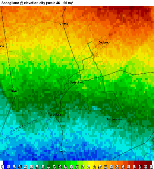
Below is the Elevation map of Sedegliano, which displays elevation range with different colors. Scale of the first map is from 46 to 96 m (151 to 315 ft) with average elevation of 68.3 meters (=224 ft) [note 1]
These maps also provides idea of topography and contour of this city, they are displayed at different zoom levels. More info about maps, scale and edge coordinates you can find below images.
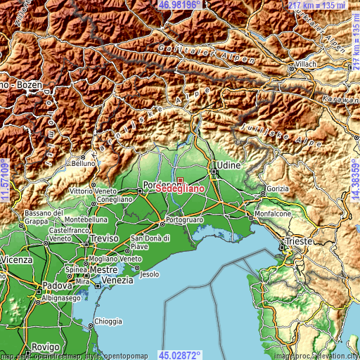
| \ | Map #1 | Topo.Map |
| Scale [m] | 46..96 m | × |
| Scale [ft] | 151..315 ft | × |
| Average | 68.3 m = 224 ft | × |
| Width | 6.79 km = 4.2 mi | 217.2 km = 135 mi |
| Height | 6.79 km = 4.2 mi | 217.2 km = 135 mi |
| ↑Max Latitude | 46.044471° | 46.98196° |
| Latitude at center | 46.01396° | 46.01396° |
| ↓Min Latitude | 45.983432° | 45.02872° |
| ← Min Longitude | 12.933395° | 11.57109° |
| Longitude center | 12.97734° | 12.97734° |
| →Max Longitude | 13.021285° | 14.38359° |
Nearby cities:
Cities around Sedegliano sort by population:
• Codroipo elevation 42 m
5.5 km,  177°
177°
• Basiliano 70 m
7.2 km,  89°
89°
• Basiliano-Vissandone 78 m
9 km,  83°
83°
• Bertiolo 33 m
9.8 km,  141°
141°
• Valvasone 54 m
8.9 km,  254°
254°
• San Martino al Tagliamento 62 m
8.3 km,  272°
272°
• Flaibano 100 m
5 km,  6°
6°
• Dignano 109 m
8.3 km,  339°
339°
• Coseano 117 m
9.7 km,  19°
19°
• San Giorgio della Richinvelda 85 m
9.2 km,  294°
294°
• Camino al Tagliamento 30 m
9.9 km,  194°
194°
• Mereto di Tomba 96 m
6.6 km,  51°
51°
Multilingual:
 En español:
Sedegliano elevación 70 m.
 En France:
Sedegliano élévation 70 m.
 Auf Deutsch:
Sedegliano höhe über dem Meeresspiegel ist 70 m.

Sources and notes:
- [note 1] Map square and city borders are not equal. Map elevation data is calculated only from area inside that square.
- [src 1] Elevation data from geonames database provided with same terms of usage.
- [src 2] The elevation map of Sedegliano is generated using elevation data from NASA's 3 arcsec (90m) resolution SRTM data.
- [src 3] Base (background) map © OpenStreetMap contributors tiles are generated by Geofabrik and OpenTopoMap.
Copyright & License:
This Sedegliano Elevation Map is licensed under CC BY-SA. You may reuse any part from this page, if you give a proper credit by linking to this URL:
 More info on terms of use page.