Stregna elevation
Stregna (Friuli Venezia Giulia, Provincia di Udine), Italy elevation is 395 meters and Stregna elevation in feet is 1296 ft above sea level [src 1]. Stregna is a seat of a third-order administrative division (feature code) with elevation that is 73 meters (240 ft) bigger than average city elevation in Italy.
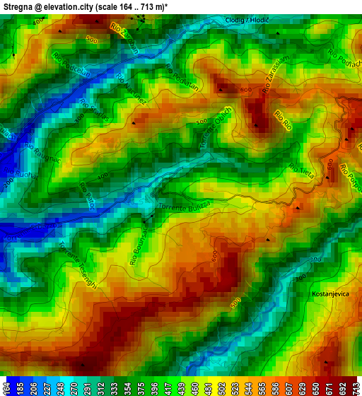
Below is the Elevation map of Stregna, which displays elevation range with different colors. Scale of the first map is from 164 to 713 m (538 to 2339 ft) with average elevation of 442.2 meters (=1451 ft) [note 1]
These maps also provides idea of topography and contour of this city, they are displayed at different zoom levels. More info about maps, scale and edge coordinates you can find below images.
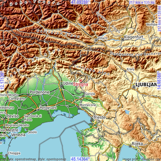
| \ | Map #1 | Topo.Map |
| Scale [m] | 164..713 m | × |
| Scale [ft] | 538..2339 ft | × |
| Average | 442.2 m = 1451 ft | × |
| Width | 6.77 km = 4.2 mi | 216.7 km = 134.7 mi |
| Height | 6.77 km = 4.2 mi | 216.7 km = 134.7 mi |
| ↑Max Latitude | 46.157338° | 47.09289° |
| Latitude at center | 46.12689° | 46.12689° |
| ↓Min Latitude | 46.096425° | 45.14364° |
| ← Min Longitude | 13.533665° | 12.17136° |
| Longitude center | 13.57761° | 13.57761° |
| →Max Longitude | 13.621555° | 14.98386° |
Nearby cities:
Cities around Stregna sort by population:
• Cividale del Friuli elevation 122 m
12.2 km,  250°
250°
• Premariacco 113 m
15.9 km,  242°
242°
• San Pietro al Natisone 158 m
7.4 km,  259°
259°
• Torreano 174 m
11.4 km,  270°
270°
• Merso di Sopra 196 m
3.8 km, 265°
• Savogna 214 m
5 km,  314°
314°
• Prepotto 105 m
11.8 km,  219°
219°
• San Leonardo 167 m
3.7 km, 256°
• Pulfero 184 m
8.9 km, 305°
• Clodig 267 m
3.5 km,  21°
21°
• Dolegna del Collio 88 m
13.1 km, 215°
• Cras 660 m
6.3 km,  33°
33°
Multilingual:
 En español:
Stregna elevación 395 m.
 En France:
Stregna élévation 395 m.


Sources and notes:
- [note 1] Map square and city borders are not equal. Map elevation data is calculated only from area inside that square.
- [src 1] Elevation data from geonames database provided with same terms of usage.
- [src 2] The elevation map of Stregna is generated using elevation data from NASA's 3 arcsec (90m) resolution SRTM data.
- [src 3] Base (background) map © OpenStreetMap contributors tiles are generated by Geofabrik and OpenTopoMap.
Copyright & License:
This Stregna Elevation Map is licensed under CC BY-SA. You may reuse any part from this page, if you give a proper credit by linking to this URL:
 More info on terms of use page.