Taggia elevation
Taggia (Liguria, Provincia di Imperia), Italy elevation is 24 meters and Taggia elevation in feet is 79 ft above sea level [src 1]. Taggia is a seat of a third-order administrative division (feature code) with elevation that is 298 meters (978 ft) smaller than average city elevation in Italy.
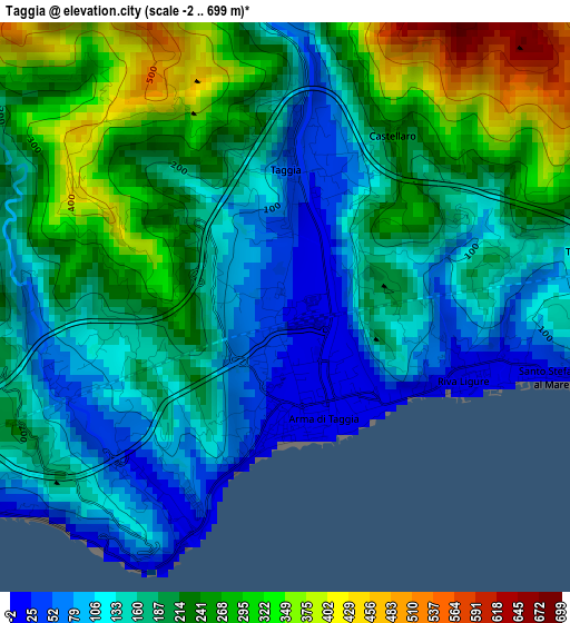
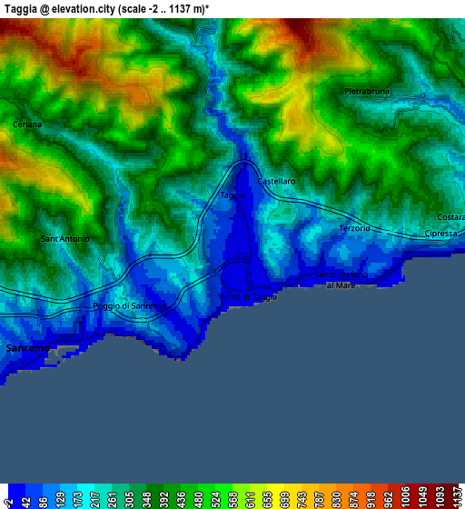
Below is the Elevation map of Taggia, which displays elevation range with different colors. Scale of the first map is from -2 to 699 m (-7 to 2293 ft) with average elevation of 192.3 meters (=631 ft) [note 1]
These maps also provides idea of topography and contour of this city, they are displayed at different zoom levels. More info about maps, scale and edge coordinates you can find below images.
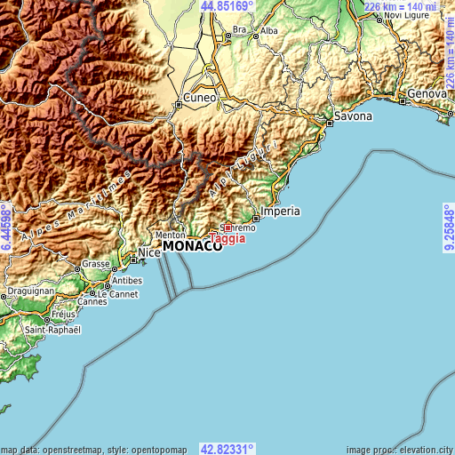
| \ | Map #1 | Map #2 | Topo.Map |
| Scale [m] | -2..699 m | -2..1137 m | × |
| Scale [ft] | -7..2293 ft | -7..3730 ft | × |
| Average | 192.3 m = 631 ft | 352.7 m = 1157 ft | × |
| Width | 7.05 km = 4.4 mi | 14.1 km = 8.8 mi | 225.5 km = 140.1 mi |
| Height | 7.05 km = 4.4 mi | 14.1 km = 8.8 mi | 225.5 km = 140.1 mi |
| ↑Max Latitude | 43.877805° | 43.909473° | 44.85169° |
| Latitude at center | 43.84612° | 43.84612° | 43.84612° |
| ↓Min Latitude | 43.814418° | 43.782699° | 42.82331° |
| ← Min Longitude | 7.808285° | 7.764339° | 6.44598° |
| Longitude center | 7.85223° | 7.85223° | 7.85223° |
| →Max Longitude | 7.896175° | 7.940121° | 9.25848° |
Nearby cities:
Cities around Taggia sort by population:
• San Remo elevation 22 m
6.8 km,  241°
241°
• Riva Ligure 13 m
2.3 km,  110°
110°
• Santo Stefano al Mare 16 m
3.7 km,  103°
103°
• Badalucco 185 m
7.9 km,  356°
356°
• Ceriana 350 m
7.3 km,  301°
301°
• Pompeiana 172 m
3 km,  75°
75°
• Castellaro 242 m
2.4 km,  33°
33°
• Costarainera 235 m
7.2 km, 82°
• Cipressa 243 m
6.4 km, 84°
• Pietrabruna 372 m
6.3 km,  40°
40°
• Civezza 230 m
8.8 km,  64°
64°
• Terzorio 197 m
3.8 km, 79°
Multilingual:
 En español:
Taggia elevación 24 m.
 En France:
Taggia élévation 24 m.


Sources and notes:
- [note 1] Map square and city borders are not equal. Map elevation data is calculated only from area inside that square.
- [src 1] Elevation data from geonames database provided with same terms of usage.
- [src 2] The elevation map of Taggia is generated using elevation data from NASA's 3 arcsec (90m) resolution SRTM data.
- [src 3] Base (background) map © OpenStreetMap contributors tiles are generated by Geofabrik and OpenTopoMap.
Copyright & License:
This Taggia Elevation Map is licensed under CC BY-SA. You may reuse any part from this page, if you give a proper credit by linking to this URL:
 More info on terms of use page.